
Community
Open Data, Open Source, Open Possibilities
Back in 2006 I (Jim) was a student at BCIT and a Vancouver resident, eager to obtain some local data for a project. I sent a hopeful email to City of Vancouver (COV) requesting the […]
Back in 2006 I (Jim) was a student at BCIT and a Vancouver resident, eager to obtain some local data for a project. I sent a hopeful email to City of Vancouver (COV) requesting the […]
The city of Ottawa has seen its urban landscape change throughout its history. As in many major cities, small buildings have been replaced with larger ones as the city grew. After Ottawa was chosen as […]
This article focuses on the process of creating a very out-of-date map in GIS. Lots has gone on since I posted Gettysburg: What Could Lee See? last summer. Technology continues to evolve at a dizzying […]
GoGeomatics has reached all the way across the world to Australia to interview our next guest. Today we have a discussion with Jennifer Johnston whom has taken the time to talk about some of her Cartography experiences and what she thinks about the Geomatics industry. […]
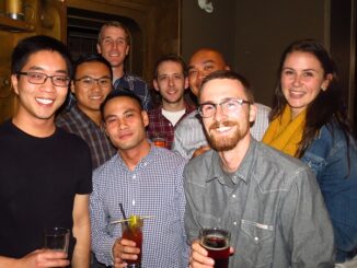
The 2nd annual GoGeomatics 2015 Back to School Socials have been a tremendous success. Last year we had 200 participants and we thought that was huge. This year we almost doubled that with 365 participants. […]
The French company PlanetObserver, specialized in imagery base map production for more than 25 years, announced the coverage of more than 50 Mill. sq km with PlanetSAT 15 L8 base map. Processed from Landsat 8 […]
For over fifty years, the islands off the coast of British Columbia and Alaska have been called ‘the outer shores’. This goes back to the pioneering exploration by Ed Ricketts, an ecologist, who gained renown […]
In February 2005, Google Maps was launched as a desktop web mapping service. A few months later, in June 2005, Google Earth was released for personal computers. Since then, people around the globe have been […]