
The Geomatics for the Public Good program at the National Expo highlights how geomatics technology is being harnessed across federal, provincial, and municipal levels to enhance public services and improve citizens’ quality of life.
Sessions: Human footprint datasets for Canada: mapping and monitoring in support of land and resource management
This talk will explore the fascinating intersection of remote sensing technology and forest ecology, focusing on how disturbances, both natural and anthropogenic, impact Alberta’s boreal forests. Attendees will learn about the Alberta Biodiversity Monitoring Institute’s innovative use of satellite data and cloud-based platforms like Google Earth Engine to monitor and analyze forest recovery post-disturbance. The discussion will highlight the creation of public datasets that reveal regional and local variations in vegetation recovery, promising new methods for characterizing recovery on industrial sites, and the potential of integrating recent lidar data. This talk promises to be engaging for those interested in cutting-edge environmental monitoring and the implications of climate change on forest ecosystems.
This talk explores the integration of advanced geospatial datasets and local knowledge to enhance landscape management planning in Alberta’s Ghost Region. By leveraging satellite-derived data from the Alberta Biodiversity Monitoring Institute (ABMI), including the Wall-to-Wall Human Footprint Inventory and Wetland Inventory, alongside insights from local communities and stakeholder groups, the presentation demonstrates how to effectively balance ecological preservation with land use demands.
Lidar and AI Based Seismic Line Mapping in Caribou Ranges in Boreal Alberta, Canada
Maintaining undisturbed habitat is crucial for the recovery strategy of the Woodland Caribou boreal population. Seismic lines, which increase predation rates by providing easy routes for predators, are a significant human footprint feature that must be accurately reported and managed. The Alberta Biodiversity Monitoring Institute (ABMI) uses advanced geospatial technologies, including high-density lidar data, satellite imagery, and machine learning, to create an updated seismic line inventory. This innovative method has dramatically increased the speed and accuracy of seismic line detection, identifying approximately 90% more seismic lines compared to previous inventories. This enhanced detection capability supports more effective habitat restoration and helps ensure the sustainability of caribou herds by maintaining the required 65% undisturbed habitat.
Large-scale habitat inventories are essential for understanding the impacts of human land use, natural disturbances, and climate change on ecological processes and species declines. In Alberta’s boreal forest, anthropogenic habitat alteration covers over 19% of the land, with much of this area not recovering naturally. The Alberta Biodiversity Monitoring Institute (ABMI) uses advanced geospatial technologies, including high-density lidar data and machine learning, to provide accurate and up-to-date information on vegetation status in these disturbed areas. Utilizing data from the Teledyne Galaxy T2000 sensor and PlanetScope imagery, ABMI models vegetation classes, height, and cover, revealing that most human footprint features are characterized by low vegetation structure and slow natural recovery. This robust workflow informs regional land use planning and management, particularly for the conservation of the threatened Woodland Caribou.
Accuracy, Uncertainty and Biases in the Human Footprint Mapping in British Columbia
Session Human footprint datasets for Canada: mapping and monitoring in support of land and resource management
Understanding human pressures on biodiversity and ecosystems is critical for effective conservation planning. This session explores the accuracy, uncertainty, and biases in human footprint mapping in British Columbia using the Human Footprint Index (HF) methodology. By analyzing multiple combinations of 16 input layers and applying the bootstrap technique, researchers identified key layers essential for accurately representing human pressures. The study also addresses uncertainties in intensity scores, which stem from expert knowledge, and examines the sensitivity of cumulative functions used in pressure mapping. Supported by comprehensive validation, the findings highlight how variations in these factors influence the outcomes of human footprint mapping.
In British Columbia, detailed human pressure mapping is essential for effective conservation and land management efforts. The Geospatial Centre of Biodiversity Pathways at the University of Northern British Columbia, in collaboration with the West Moberly First Nations and the Alberta Biodiversity Monitoring Institute, is pioneering the creation of the first high-resolution, thematically complete maps of human pressures across the province. This foundational map covers 68 types of human pressures, including agricultural, forestry, transportation, urban, energy, and human-created water bodies. It has been crucial for cumulative effect assessments within the Peace River watershed, aiding in land-use planning for the West Moberly First Nations. Current efforts focus on enhancing the accuracy of mapping oil and gas activities through visual interpretation and manual digitization of high-resolution imagery.
High-resolution regional climate modeling from the Prairie Adaptation Research Collaborative (PARC) offers future climate projections at 3 km spatial resolution and sub-daily temporal scales. This presentation provides an overview of how this data is leveraged within a simple GIS framework to enhance climate adaptation, using a vulnerability risk assessment of Edmonton Regional Municipality as an example.
Geo-Entrepreneurship: Navigating Your Geospatial Business
Join us for an engaging panel discussion on Geo-Entrepreneurship, featuring distinguished experts from geospatial consultancies, geomatics communication and event companies, and geomatics software firms. This session is designed for those interested in the intersection of geospatial technology and entrepreneurship.

The Effect of Creative Teaching and Radical Constructivism in Geomatics Education
Traditional teaching methods in post-secondary often included using PowerPoint presentations and writing on a white or blackboard. The newer generations of students have been exposed to different ways of learning and this requires instructors or teaching professors to change their way of presenting information to help the students learn it at a deeper level. Using a radical constructivism philosophy, the students are required to engage in the material in their own way, connect with their classmates in learning the information, and use previous knowledge to learn more. This presentation will discuss different techniques that have been applied in theoretical and software classes and will describe the instructor’s observations of how the students learn or engage in the material differently. These concepts can be used in facilitating in any learning or training environment.
Multi Disciplicinary Geomatics for Environmental Mangement
How do hydrographic surveys, aerial Remote Sensing and GIS help with environmental efforts? Terra explores 3 projects that use a combination of different sensors and visualizations to achieve these goals. The projects include a rapid marine data collection to support a trapped Orca, an ongoing canopy assessment to aid in city planning with environmental monitoring and remediation of a legacy mine.
Transforming Urban Accessibility with Geospatial Solutions
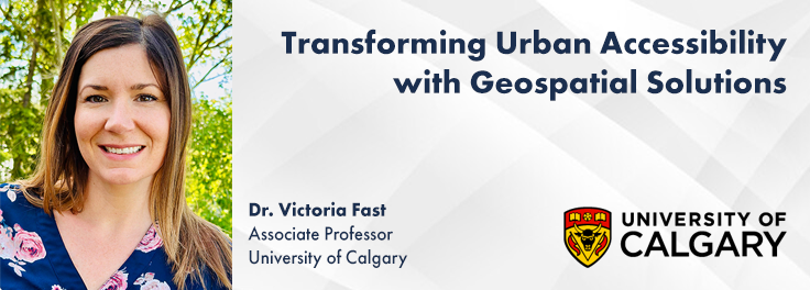
This talk begins by illustrating the problem with real examples of accessibility fails on platforms like Google Maps. Attendees are encouraged to check accessibility features on their phones, highlighting current gaps.
We will then explore the necessity of specialized tools for meaningful navigation and destination planning for people with disabilities, featuring innovative mapping solutions like Pedesting, a local Calgary startup, and AccessNow, a project originating in Toronto but making significant strides in Calgary with the Mapping Our Cities for All (MOCA) project.
To support and expand our capacity for this crucial work, I introduce UCAN (University of Calgary Accessibility Network), an initiative dedicated to fostering community, scholarly, business, and government collaboration, furthering accessibility research and implementation.

Thank you to our sponsors!
Platinum Sponsor

Bronze Sponsors


Event & Media Sponsors


Be the first to comment