PredictION helps citizens understand the impact of proposed transit changes to their daily commute
TORONTO – Esri Canada congratulates Jonathan Van Dusen, Majuratan Sadagopan and Shanqi Zhang from the University of Waterloo for winning the Esri Canada GIS Centres of Excellence in Higher Education App Challenge. The week-long coding competition encouraged students within the network to build innovative Web apps that use open data and Esri’s geographic information system (GIS) technology to address a specific theme. Working as a team, the three students developed PredictION, a transit modeling and routing application that helps citizens to visualize, analyze and compare routes and service areas between existing and proposed transit systems.
“PredictION is an excellent example of how governments, such as transit authorities, can use spatial Web apps to engage citizens in new projects,” said Dr. Brent Hall, director of education and research, Esri Canada. “It’s a powerful and practical tool for informing citizens of possible changes in the transit system, allowing them to make better travel decisions and improve their quality of life.”
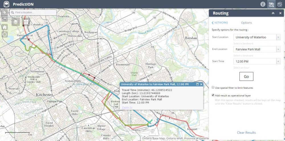
 This shows routes between the University of Waterloo and the Fairview Park Mall in Kitchener using the existing Grand River Transit network (blue, selected) and the same network with the ION Rapid Transit line added (green), at 12 pm on a normal weekday.
For the competition, the team used PredictION to demonstrate the impact on travel times and service areas of the coming ION Rapid Transit lines to the Region of Waterloo’s Grand River Transit network. They used Esri’s ArcGIS platform to integrate, process and display various open datasets including road and bus networks, transit routes and schedules, regional boundaries and local points of interest. They also used Web AppBuilder for ArcGIS (Developer Edition) to create a highly visual and easy-to-use analysis tool for comparing current and proposed transit services.
“Esri’s new Web AppBuilder enabled us to easily include our transit map and data from ArcGIS Online,” said Jonathan Van Dusen, who co-developed the winning app. “The time we saved using Web AppBuilder allowed us to spend more time on the data analysis at the heart of our app’s functionality. The Network Analyst, ModelBuilder and Python scripting tools in ArcGIS for Desktop also made it easy to automatically create the transit routes and service areas for our app.”
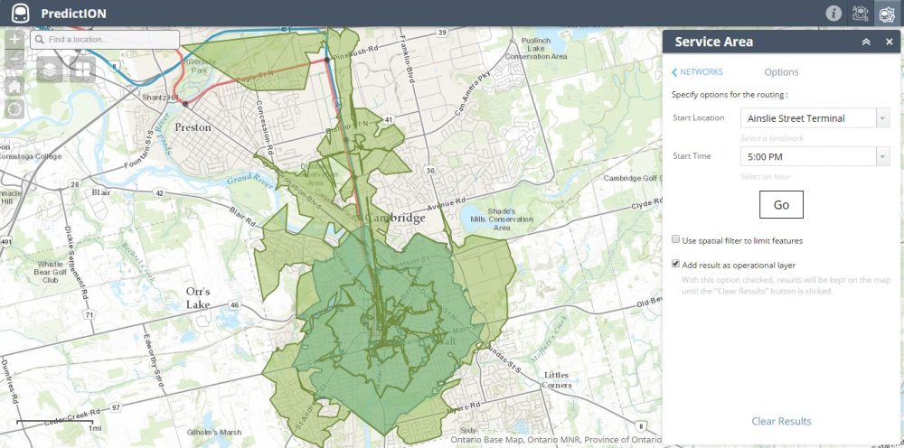
 This shows the 10-, 20- and 30-minute service areas from the Ainslie Street Terminal in Cambridge, at 5 pm on a normal weekday, with the existing network’s service areas in teal and the new network’s service areas in green. Note: In both cases, analysis for the new network is based on a hypothetical transit schedule based on assumptions from Grand River Transit. The new network’s routes and service areas are presented for demonstration purposes only.
PredictION was selected by a panel of GIS and industry experts out of 10 entries. As part of their prize, the team will go on an all-expenses paid trip to the Esri International User Conference in San Diego this July.
To view all App Challenge entries, visit: https://github.com/EsriCanada-CE/ecce-app-challenge-2015.
About the Esri Canada GIS Centres of Excellence in Higher Education
Launched in 2014, the initiative is aimed at encouraging innovation in GIS research and promoting teaching excellence in spatial data management and analysis in higher education across Canada. The Centres will also increase the opportunity for inter-institutional collaboration across the country and help expand spatial thinking and GIS software use beyond the traditional field of geography. To learn more about the initiative and participating institutions, visit ecce.esri.ca.
About Esri Canada
Founded in 1984, Esri Canada provides enterprise geographic information system (GIS) solutions that empower businesses, governments and educational institutions to make timely, informed and mission-critical decisions by leveraging the power of geography. The company distributes the world’s leading GIS software from Esri, Schneider Electric, Cityworks – Azteca Systems, Inc. and other technology partners. Headquartered in Toronto, the company serves over 10,000 customers from 16 regional offices across Canada. Esri Canada has joined the elite rank of Canada’s Best Managed companies and has been named to the Branham300. Information about the company can be found at esri.ca. Follow Esri Canada on Twitter, Facebook, YouTube and LinkedIn.


Be the first to comment