
Where are the Geospatial clouds? 
Will Cadell of Sparkgeo is often asked about geospatial platforms. Clouds are a great low cost, low-risk solution for industries; these facts lead start-ups and tech companies investing in cloud technologies on which to put their brand new code, but not buying geospatial clouds in favor of obtaining full stack technology. The geospatial community is lacking a cloud toolkit—but Cadell sees solutions that could come from industry leaders like ESRI, Boundless and Mapbox.
UK-made satellites have Indian launch
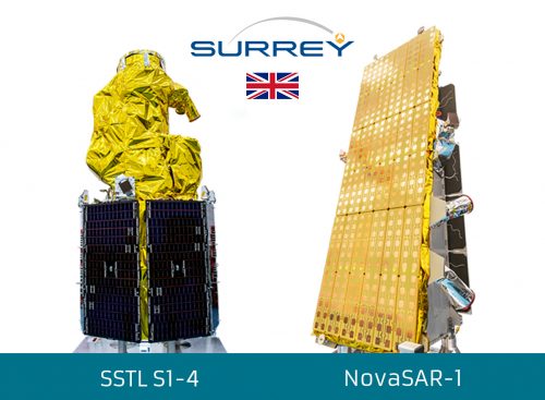
The commercial arm of the Indian Space Research organization has just launched the UK-made satellites NovaSAR-1 and S1-4. NovaSAR-1 is a synthetic aperture radar spacecraft, the first to be built entirely in the UK. As an increasingly popular technology for commercial Earth observation, SAR’s remote sensing capabilities and services will now enhance Earth images with a sub one-meter optical mission. S1-4 is a visual imaging system that provides sub one-meter resolution data and is capable of observing multiple subjects in a single pass of about 24km wide.
The GIS community comes together for Geo Week
Three major geospatial events—the International LiDAR Mapping Forum (ILMF), ASPRS Annual Conference and MAPPS Winter Conference—have joined forces to create Geo Week 2019 in Denver. The vendor-neutral networking event will provide distinct educational programs from each major participant and offer industry news and career development resources. With a year’s worth of geospatial business taking place over the course of seven days, Geo Week is poised to become a major annual event for mapping and remote sensing.
Disaster response drones

Using unmanned aircraft systems to serve public safety in the aftermath of catastrophic events is nothing new, but while ordinary aircrafts wait out the worst of the storm we will soon be seeing pre-positioned drones taking to the air to gather high-resolution imagery. Drones are steadily evolving to assess situational awareness, damages, search and rescue, news/public information gathering, critical infrastructure inspection, telecommunications and power restoration, aerial mapping, and insurance claims processing. The recent landfall of Hurricane Florence will likely render new evidence for the effectiveness of unmanned aircraft systems in revolutionizing disaster management.
New AI locates at-risk dams
A project at Columbia Water Centre is helping to repair or decommission over 88,000 dams in the United States that may cause injury and death in the event of a collapse. Using climate models, GIS data, and artificial intelligence, the team at the center pinpoints the most endangered damns as climate warming increases the chances of heavy rains and flooding. Currently, AI is being combined with the climate data model to map transportation, electricity generation, population, and wastewater treatment infrastructure. The final model will hopefully be ready by 2020.

Be the first to comment