
goals

The “New” GoGeomatics Canada: Relaunching Our Magazine
A team of really intelligent squirrels and I have been working on the new GoGeomatics magazine. I’m taking a break…

CANMAP, and SHIFTing gears at COGS
At the end of last month, John Wian hosted the Annual General Meeting (AGM) of the CANMAP Research Institute in…

March 2017 GoGeomatics Talks: Toronto, London, Peterborough, Halifax
GoGeomatics Canada has built a thriving geospatial community by creating networking opportunities for our participants. We achieve this by holding free informal…
Free Webinar March 15th: NRCan, OGC, & USGS Arctic Spatial Data Pilot Demonstration
The Canada Centre for Mapping and Earth Observation invites you to attend the Arctic Spatial Data Pilot Demonstration Webinar. Managed and…

GNOSIS – A New Geomatics Software Suite
Creating a new GIS from scratch is a tough undertaking. It involves a lot of innovation. Ecere, a Canadian company…
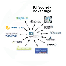
The Integrated Cadastral Information (ICI) Society and ParcelMap BC
This is the first of two articles on the release of ParcelMap BC Data, which we see as a significant…

Upgrade your Geospatial Skills: leveraging the power of MOOCs
What I want to share with you are some resources related to something called Massive Open Online Course (MOOC) where…

Easy Access to Data: The CGDI Initiative
The Canadian Geospatial Data Infrastructure (CGDI) is an initiative of Natural Resources Canada that began in 2001. The CGDI does…

Ten Online GIS Programs in Canada
After completing an undergraduate degree in 2015, (Geography and Environmental Studies at the University of Toronto) I needed to determine…
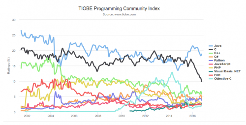
What are the Top Programming Languages in the GIS World?
Image source: www.tiobe.com Every now and again we hear about the importance of programming for Geographic Information Systems(GIS) professionals, that…

DigitalGlobe’s Basemap Suite Expands: 250 Million Square Kilometers of 30 cm Imagery
DigitalGlobe, Inc. (NYSE: DGI), the global leader in Earth imagery and information about our changing planet, today announced that its…

Canadian GIS Ambassador Program: Interview with Brent Hall, Director of Education & Research at Esri Canada
Interview with Brent Hall, Director of Education and Research at Esri Canada and, along with his staff, the initiator of…
