
topobathymetric
NV5 Geospatial Supports Flood Risk Mapping in Montreal Through Canada’s Largest Riverine Topobathymetric Lidar Survey
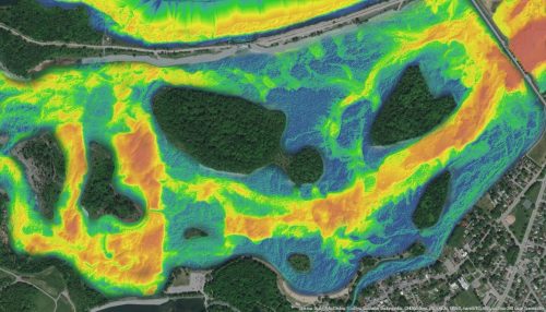
The Greater Montréal Area completed Canada’s largest-ever riverine topobathymetric lidar survey inresponse to two major flooding events within the last…
GeoIgnite Talk On YouTube: A closer look at the NV5 Geospatial 2020 aerial topobathymetric lidar survey of Montreal
In case you missed it GoGeomatics is highlighting one of the most interesting talks from GeoIgnite from this past April.…
