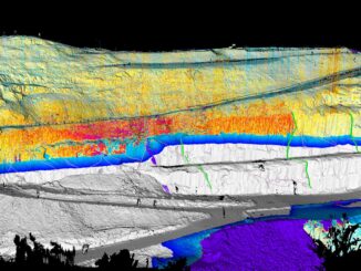
• facebook
  • Twitter
  • Linkedin
  • Youtube
  • Linkedin Group
  • Post a Job
  • Post an Ad
  • Post an Event
  • Post a Directory Listing
  • Post a Press Release
  • Media Kit
  • My Account
  • Login
GoGeomatics
  • MAGAZINE
    • BIM & GIS
    • Community
    • Conference news
    • Earth Observation
    • Education & Careers
    • GEOAI
    • Announcements
    • Reality Capture & Lidar
    • Science
    • Technology
    • Between the Poles
  • Directories
    • ASSOCIATION
    • INDUSTRY
    • EDUCATION
    • Open Data
  • EVENTS
    • GeoIgnite Events
    • Events Calendar
    • GoGeomatics Meetups
  • Services
    • Advertising
    • Marketing
    • Post a Job
    • Post an Ad
    • Post an Event
    • Post a Press Release
    • Post a Directory Listing
    • Media Kit
    • Web Design
  • Find a Job
  • Volunteer
    • Start a GoGeomatics Group
    • Editors & Writers Group
  • About Us
    • About Us
    • Contact Us
    • Frequently Asked Questions
  • Videos
Home2017

Year: 2017

3D data

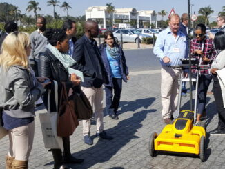
Geospatial technology captures wall instability and collapse in an open pit mine

16 August 2017 Geoff Zeiss

One of the most exciting presentations at the SA Geotech conference in Johannesburg was a presentation by Jason Richards of Maptek.  He talked about using geospatial technology to map in space and time the instability and […]

||||||
Technology

An Introduction: GIS and GPS for Precision Agriculture

15 August 2017 Murrium Zaheer | farming

Have you ever felt lost when someone started talking about precision agriculture?  When people think about a GIS intensive environment, they probably imagine a bustling office where the inhabitants are using technology (i.e. their computers) […]

|||||||
Technology

Leaks: Using GIS to Explore Canadian Tax Cheaters from the Panama Papers

10 August 2017 Tyler Collins | Calgary

The Breaking News Last year, the International Consortium of Investigative Journalists announced that a year prior, one of their members (Süddeutsche Zeitung) had been sent the contents of a massive leak from the Panamanian law […]

|||||||||
Technology

Fire GIS Uses Maps, Data, & Social Media–A Hot Tool for BC Residents, Travellers

8 August 2017 Dianne Gray | ArcGIS Online

Every summer in British Columbia, along with long days, sunshine, heat, and little rain comes an all-too-familiar reality: hundreds of wildfires. Some of them affect only uninhabited regions in BC, but many threaten communities, property, […]

Asset management

Open source geospatial application reduces copper cable theft by 70%

7 August 2017 Geoff Zeiss

A highlight of the SA Geotech conference in Johannesburg was a presentation by Ryno Goosen of Suritec Geospatial.  Ryno, who was awarded the Best Paper prize at SA Geotec, gave a fascinating presentation about how he […]

||||||||||||||||||||||||||||||||||||||||||
Community

Montreal 2017 EO Summit: Is Earth Observation becoming a global partnership for change?

2 August 2017 Theresa Pinter | 2017

My journey to the 2017 Earth Observation (EO) Summit in Montreal began when I boarded the train and left Union Station in Toronto. During the long train ride I had the chance to think about […]

|||||||||||||||
Technology

Using Swipe Maps to View Wildfire Destruction in BC

31 July 2017 GIS Program Langara CS | BC

On July 7, 2017 a series of devastating wildfires began in the Cariboo region of British Columbia. The effects of these wildfires will take much time and many resources to make recovery. GIS can have […]

3D data

Growing interest in underground utility detection in South Africa

27 July 2017 Geoff Zeiss

In South Africa there appears to be growing interest in underground utility detection.  One of the highlights of the SA Geotech conference in Johannesburg where I had been invited to give a keynote was a demonstration […]

Posts pagination

« 1 … 7 8 9 … 28 »

Events

Notice
There are no upcoming events.

View All Events

Services

  • Post a Job
  • Post an Ad
  • Post an Event
  • Post a Directory Listing
  • Post a Press Release
  • Media Kit
  • My Account
  • Login

Jobs

Post a Job
  • Volunteer Editorial Contributor – Be Part of Canada’s Geomatics Story
    Remote
  • Junior Geomatics Field Technician – Technical Surveys
    Montréal, QC
  • GIS Specialist
    Amherst, Nova Scotia
  • Precast Structural BIM Specialist
    Calgary, Alberta
View All Jobs
  • Directories
    • Associations Directory
    • Industry Directory
    • Education Programs
    • Open Data
  • Volunteer
    • Start a GoGeomatics Group
    • Editors & Writers Group
  • About Us
    • GoGeomatics Media Kit
    • Who We Are
    • Contact Us
    • FAQ’s
    • Advertising
    • Marketing
  • Subscribe
GoGeomatics
GoGeomatics is the largest and most popular communications hub promoting the Canadian geospatial community. The business was incorporated in 2011. GoGeomatics hosts over 100 fun, free, location technology networking events each year in cities across Canada.

© 2026 GoGeomatics

  • facebook
  • Twitter
  • Linkedin
  • Youtube
  • Linkedin Group