
- Teaching drones to think: UVic’s AI-powered aerial mapping system
- ‘Avoid the honk’: Interactive map helps Waterloo students stay away from Canada geese
- 33 glacial lakes hidden under the Canadian Arctic mapped
- Saab dangles sovereign data centre in Montreal to undercut F-35 fighter contract
- Canada formalizes subscriptions to four new European Space Agency programs
- Alberta Data Partnerships Ltd. (ADP) announced the launch of the Open Data Areas Alberta Modernization project
- Croptimistic’s SWAT Cam maps one million acres in Western Canada
Teaching drones to think: UVic’s AI-powered aerial mapping system
Homayoun Najjaran, professor of mechanical engineering at the University of Victoria (UVic), is using AI powered drones to help with aerial mapping systems. Najjaran’s focus on machine learning led him to develop “a drone that can fly into an environment it has never seen before, survey it, and build a detailed three-dimensional model, entirely on its own”.

The biggest challenge is independently mapping unknown environments in high-resolution 3D for environments the drone has no previous data on. The real world applications involve disaster response and military defence applications. Both require high degree of accuracy and speedy turnaround to create deliverables that can be applied in these high stress situations. Read in more detail on Homayoun Najjaran drone machine learning here.
‘Avoid the honk’: Interactive map helps Waterloo students stay away from Canada geese
Anirudh Dabas, a University of Waterloo student, “launched an interactive goose map, called Waddleloo, to help students navigate the problem of “aggressive geese” on campus”. Users can upload goose sightings to the platform which helps path-find the safest routes across campus similar to google maps.
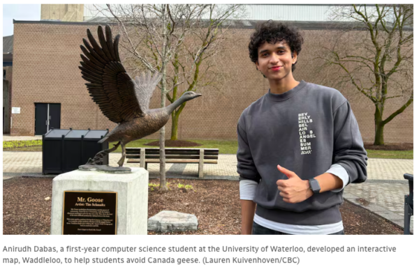
The proximity buffer and route finding applications of GIS software are versatile tools and are being used for numerous other solutions and data finding problems such as navigating around Canadian Geese. Users upload photos of goose sightings and flag the locations on the map. Paired with AI photo analysis, the algorithm can distinguish goslings from other objects and geese. Read more on this project here.
33 glacial lakes hidden under the Canadian Arctic mapped
Canadian scientists have used decade-long satellite elevation data to create the first detailed map of active subglacial lakes in the Canadian Arctic. They identified 37 lakes, 33 of them previously unknown, hidden beneath glaciers. The study found that these lakes rapidly fill and drain, causing the ice above to rise or fall by over 100 meters per year.
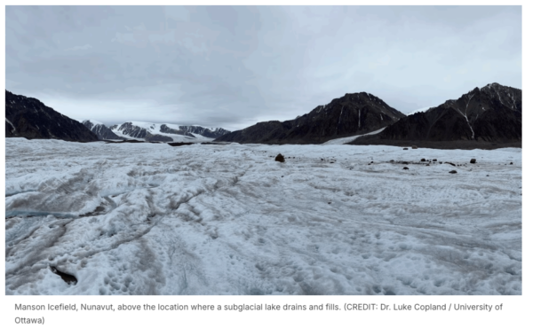
The findings help understand how hidden water beneath glaciers is important for accurately track ice loss and refine sea-level rise projections. This showcases how Geospatial Technology and Surveying can find solutions and hidden data with the right tools. Read more about these findings here and here.
Saab dangles sovereign data centre in Montreal to undercut F-35 fighter contract
The Swedish defence company Saab has offered to build a sovereign data centre in Montreal as part of its bid to supply Canada with fighter jets. This action is directly tied to keeping critical, top-secret mission data and intelligence away from The United States and stays in national Canadian borders.
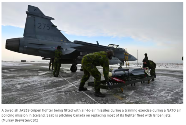
This ties to the world actively moving towards independent data sovereignty, and Canada needs to strongly consider doing the same with all forms of data and critical information. From a geospatial perspective, North America through the North American Aerospace Defence Command (NORAD) being a geospatial intelligence hub and the jets requiring data centers not only for top security information but navigation ties everything together for the importance of geospatial data sovereignty. Read more here.
Canada formalizes subscriptions to four new European Space Agency programs
The Canadian Federal Government is formally participating in a new suite of European Space Agency (ESA) programs. The purpose is to grow international space partnerships and formally sign four multilateral ESA initiatives: Moonlight, FutureNAV, ACCESS, and the European Resilience from Space for Earth Observation (ERS-EO) Programme. The one initiative that sticks out the most from a geospatial perspective is The FutureNAV Programme.

This program is said to establish “next-generation Positioning, Navigation, and Timing (PNT) technologies”. Although it does not go into much detail on this process, it does involve on building off of existing GPS/Galileo networks. Space exploration heavily relies on geospatial technologies and procedures and will play a substantial role when space travel becomes more prevalent. Read more here.
Alberta Data Partnerships Ltd. (ADP) announced the launch of the Open Data Areas Alberta Modernization project
Alberta Data Partnerships Ltd. (ADP) has announce the launch of the Open Data Areas Alberta Modernization project. Environmental Innovation program in Alberta has invested $500,000 for Open Data Areas Alberta (ODAA) which is providing “geographically defined zones across the province where no-cost, openly licensed geospatial datasets are freely available for evaluation, research, and innovation”.

The projects aim is to modernizes the existing programs. These include:
- Existing Open Data Areas will be refreshed with updated and expanded datasets.
- The program will expand to include new geographic areas that are selected through structured stakeholder engagement.
- The platform will integrate a new Registered Interests on Title Land (RITL) layer to link EO directly to legal land interests enabling more accountable, defensible, and operationally useful analytics.
“By harmonizing environmental, terrain, infrastructure, and legal tenure data across defined geographic areas with consistent documentation and metadata, ODAA reduces the key barrier to applied AI/ML in Alberta’s environmental sector: the lack of standardized, well-documented training datasets”. Read more here.
Croptimistic’s SWAT Cam maps one million acres in Western Canada
The Saskatoon company, Croptimistic, is onboarding an imaging tool that captures field conditions with machine learning tactics. Thousands of images are analyzed to generate crop and weed maps. The product is called SWAT Cam system and has gone through a very procedural testing phase before reaching a commercial user base.
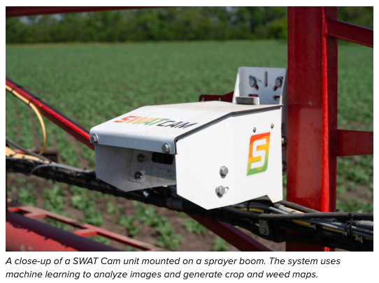
The platform divides fields into management zones based on soil, water, and topography. From a geospatial perspective, this showcases the utility of mapping technology and how entrepreneurial businesses can use these tools for niche circumstances which serve the community in monitoring and data collection. Read more about Croptimistic and SWAT Cam here.


Be the first to comment