
In January each year, the Centre of Geographic Sciences (COGS) combines an industry expo with a two day conference. This year, the theme was Geotechnologies for Resource Management.
Day 1
The first presentation was by Eric Langin, Eagle- GIS. They illustrated their mobile mapping solution for asset mapping. The case study was signage, fire hydrants, manholes at Cornwallis Park. They are also working on machine learning to identify municipal assets. Tim Webster followed up with a presentation on topo-bathymetric LiDAR for flood risk mapping. This included case studies in the River John and Lahavre River. He illustrated the integration of hydrodynamic models with LiDAR derived digital elevation models. Barry and Noah Stevens from 3D Wave Design illustrated their approach to communicating climate risks through 3D mapping. Their target audience are citizens and councillors at the municipal level. They illustrated their philosophy: observe, plan, adapt with case studies from Mahone Bay and First Nations communities. They have been working collaboratively with Tim Webster’s AGRG team.
After lunch, Leif Helmer, Chair MTRI Board and NSCC faculty, provided an update on their citizen science agenda, as well as the non-profit collaboration with CARP and Coastal Action. It includes species at risk, forest stewardship and other place-based research.
Kate Collins described the new NSCC approach to Innovation and Industry Engagement. Followed by Paul Illsley’s detailed description of AGRG research with multispectral and hyperspectral sensors.
The final session started with a remote presentation by Pierre Markuse, Germany. He makes high quality satellite imagery available to a variety of media audiences. Examples include the latest forest fires in Australia.
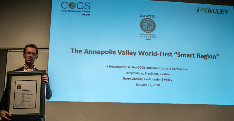
Terry Dalton closed the day with a presentation on I-Valley, defined as the world’s first ‘smart and sustainable rural region’. My only quibble was that the Valley was defined according to the municipal participants of the Valley REN. For political reasons, this does not include Annapolis County or COGS in Lawrencetown. A missed opportunity !
Day 2

We started early with a breakfast presentation by Hugh MacKay, MLA Chester-St Margaret’s. Hugh clarified his role in government and his views on Geomatics, as a career practitioner. His message was the need for more Geomatics jobs in Nova Scotia and the potential of the new Innovation Hub on the COGS campus. The new hub(expansion) will be available in 2021.
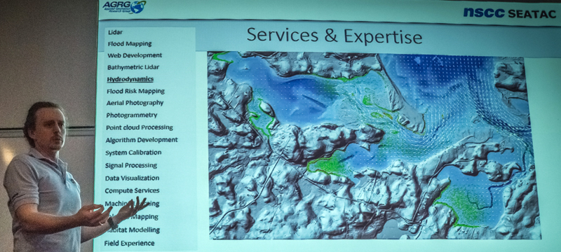
Linzey Bedard, Fathom Studio described the historical and cultural research associated with the new NSCC campus on the waterfront in Sydney. This was complemented by Kevin McGuigan’s presentation on the SEATAC (Sensing, Engineering and Analytics Technology Access Centre). One of thirty TACs funded by the federal government across Canada. Kevin gave an excellent detailed description of the technologies which are available at AGRG, from topo-bathymetric LiDAR to drones and virtual reality environments, plus the associated software.
I had to step about before lunch, and missed Peter Simpkin’s presentation on sediment profiling, however I did catch Matt Bilodeau on optimizing corn harvest with remote sensing and Aaron Farkus on the new dynamic hydrographic charts from CHS.
Summary
The conference was titled Geotechnologies for Resource Management. From Tim Webster and Kevin McGuigan, it is evident that AGRG has amassed significant Geotechnologies which have the potential for better management of our coastal zone and to plan for the impact of climate change. This technology should be accessible through the SEATAC and the Innovation Hub at COGS. A good example of collaboration was illustrated between AGRG and 3D Wave Design.
If we look at the resource management concerns in Nova Scotia and the application of these technologies, there is abundant opportunity for evidence-based resource management in forestry, agriculture, mining and fisheries. The key is the relationship between the relevant sciences and the appropriate use of Geotechnologies. That is the challenge for SEATAC and the Valley region Innovation Hub. It is certainly going to test the boundary conditions of the I-Valley.
Event Review – COGS Conference 2020 from the Ernest Blair Experiment.


Be the first to comment