
Global forests are one of our most important resources, not only for the service they provide as the lungs of the earth but also as a renewable and reliable resource for many people in industrial economies around the world. However, sustainable management practices are key to ensuring the continuity of this resource for future generations to rely on.
Satellite imagery has changed the way we see forests, allowing us to have a birds-eye view that provides context and scale we could not otherwise see. For instance, the Amazon rainforest covers 9 countries and over 6 million square kilometres of land, so despite anyone’s best efforts, it is incredibly hard to gain an understanding of all facets of the forest at once.
Understanding forests like never before
AI tools are helping us overcome this obstacle, as they allow researchers to quantify and understand the forest like never before. Project Guacamaya in the Amazon aims to develop a deeper level of understanding of forest dynamics through a three-pronged approach. By gathering data from partners Planet Labs PBC and the NICFI program, authorities in Colombia can look for telltale signs of deforestation or mining in prohibited locations. As satellite data can only give an aerial view of what is happening below, scientists need other methods to understand what is accurately happening on the ground. This has led to two unique ideas that have been complemented by AI to gain a deeper insight.
The first is using soundscapes to see if it can help understand the health of a forest on the basis that as landscapes change from forest to farmland, the sounds of the environment will change with it. By assessing the sounds of a landscape based on the “vocal vertebrates,” mainly birds, amphibians, and a few mammals, they can create a picture of forest health and biodiversity. Given the opportunity to test their theories working on an NGO-created reserve in Ecuador, Jörg Müller and his team set up their listening devices on a wide variety of landscapes, from old-growth forests to abandoned and recovering plots, ranging from 2 to 30+ years in recovery to forests actively being harvested.
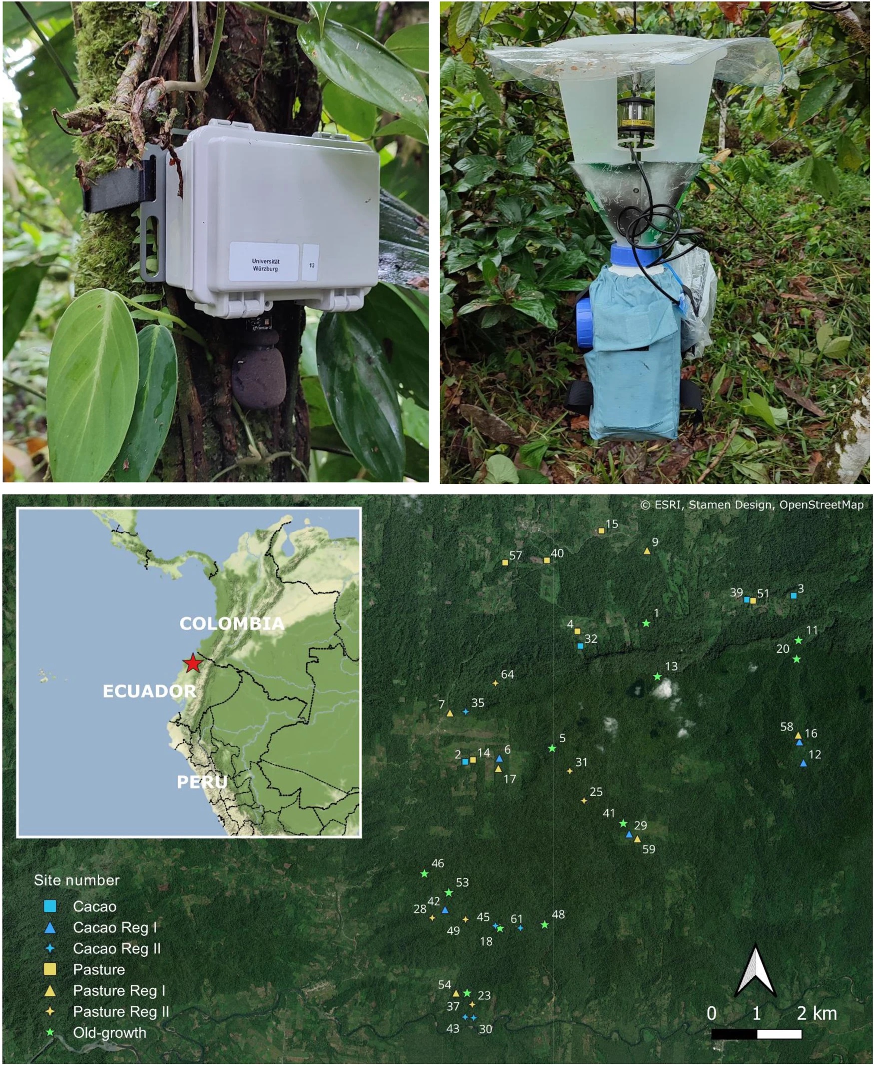
Through first using experts to help in species identification and then subsequently checking the data against machine-learning using a convoluted neural network, the team found the AI outperformed combinations of different acoustic indices, “demonstrating that community composition estimated from CNN is a promising way to track faunal recovery of tropical forest communities.”
Scientists also worked with tree-mounted cameras, or camera traps, placing them throughout the forest and collecting the motion-activated images. Researchers then trained an AI model to help identify the animals captured in the images, which is now running at 97% accuracy, with manual validation down to roughly 10% of the images. The image-classification AI helps the team expand and deepen their research, while also offering early insights into ecological shifts in an environment, which can then be addressed promptly.

Protecting forests in real-time
Switzerland-based Picterra has developed an API for their AI and machine-learning interface that has been used to contribute to illegal logging monitoring, reforestation efforts, and uses machine-learning to monitor sites at scale. The AI can be used to identify areas of a forest that are degraded or in need of urgent attention, providing governments and other organizations with a tool that allows them to target their limited resources to the areas of greatest need, increasing their ability to have a meaningful impact.

However, it is the speed and efficiency that AI and machine-learning provide, when coupled with geospatial intelligence, that makes the real difference when it comes to forest protection efforts. Illegal logging remains a major problem around the world, and while conventional efforts like hiring rangers can help, the sheer size of some of these forests makes those efforts feel ineffective at best.
Picterra has partnered with SGS to help fight deforestation in Liberia. Using data from the Sentinel constellation, they feed the images into a trained machine-learning solution. The reliable workflow uses the rapid revisit time of 5 days for Sentinel, providing a non-invasive, repeatable method for identifying illegal deforestation, which can then be used to alert authorities, who can carefully direct their resources to the affected regions. As briefly discussed above, this process is very similar to the Geospatial AI-centric approach being undertaken in the Colombian Amazon project. Trained AI models can analyze these images over time and help pinpoint locations that are being illegally deforested.

And while it is nice to have these tools that allow us to quickly identify and address issues such as deforestation or poor forest health, the ideal solution would be to create an AI that helps prevent these issues in the first place.
Can we stop deforestation before it happens?
That is exactly what researchers from the environmental non-profit Imazon hope to achieve with their new tool, PrevisIA. Tired of just repairing the damage done in the Brazilian Amazon, PrevisIA was created to use AI and machine-learning to instead predict where deforestation will occur before it does.
By feeding in data concerned with local trends of deforestation from Prodes, the government’s annual monitoring system, the system can identify regions that are more likely to be affected negatively by deforestation soon. Tobler’s first law of geography applies here, in that near things are more related than distant things, meaning areas close to others where deforestation has already occurred are more likely to be the next targets.
It also highlights regions with conditions that are likely to contribute to deforestation such as population density, road infrastructure density, and proximity to both urban and rural settlements. There is an emphasis on tracking the development of roads through these remote areas, as they are often illegal roads which facilitate the deforestation process, but as they often precede the operations, their identification is critical.
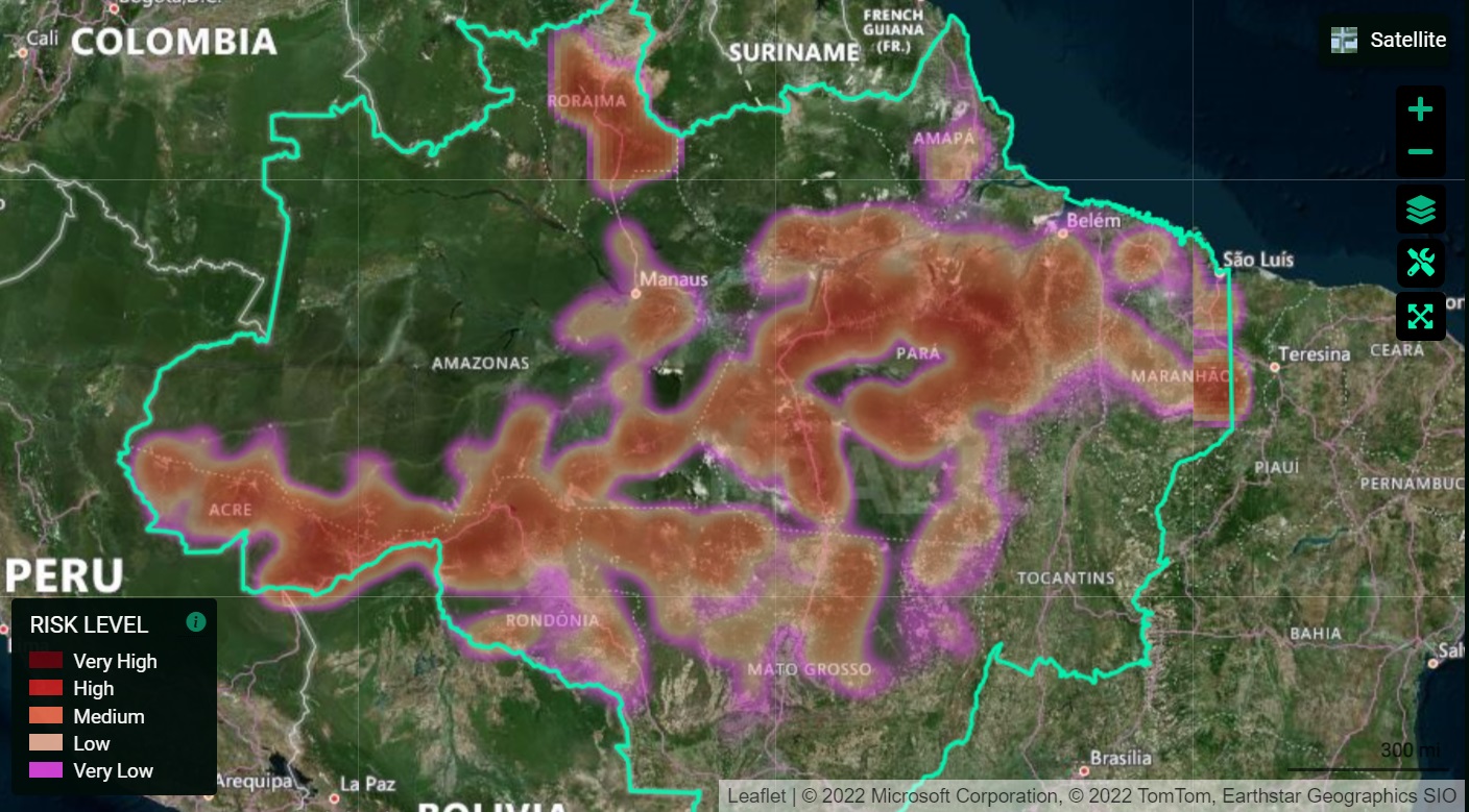
However, there is also data worked into the model that accounts for factors that are more likely to result in forests remaining untouched and protected. This included bodies of water and other terrains that are not ideal for logging operations, presence of protected lands (Indigenous and Quilombola communities), and more.
Running the model (see above) provides predictions for the areas that are most at risk each year and can again help governments and other organizations allocate resources to ensure that extra protection be given to these areas. In 2023, the model predicted Triunfo do Xingu (a Brazilian APA or Environmental Protection Area) as one of the most vulnerable APAs in the region. Home to countless endangered species and a unique biodiversity hot spot, this allowed authorities to target their protection efforts in hopes of preserving the unique wild environment.
PrevisIA’s accuracy has proven important so far, with 85% of deforestation alerts having been within 4km of the predicted location and 49% of alerts in areas of high or very high risk. The team is constantly improving their model, but they hope to one day get it wrong. “If that happens,” says Carlos Souza Jr, senior researcher at Imazon and project coordinator of PrevisIA, “it’ll mean prevention is working.”
Further Reading
[1] https://www.gim-international.com/content/news/harnessing-geospatial-ai-for-forest-conservation
[2] https://www.sgs.com/en/news/2021/01/protecting-the-worlds-forests-with-machine-learning-and-satellites
[3] https://news.microsoft.com/source/latam/features/ai/amazon-ai-rainforest-deforestation/?lang=en
[4] https://www.theguardian.com/technology/2023/apr/29/could-ai-save-amazon-rainforest-artificial-intelligence-conservation-deforestation
[5] https://imazon.org.br/en/imprensa/artificial-intelligence-platform-estimates-deforestation-risk-of-15-thousand-km%C2%B2-in-the-brazilian-amazon-in-2022/
[6] https://picterra.ch/blog/ai-enabled-forest-monitoring-a-new-tool-for-combating-deforestation/
[7] https://picterra.ch/blog/how-geospatial-ai-can-help-you-comply-with-eus-deforestation-law/
[8] https://www.linkedin.com/pulse/using-ai-protect-amazon-juan-m-lavista-ferres/
[9] Müller, J., Mitesser, O., Schaefer, H.M. et al. Soundscapes and deep learning enable tracking biodiversity recovery in tropical forests. Nat Commun 14, 6191 (2023). https://doi.org/10.1038/s41467-023-41693-w


Be the first to comment