
The future holds great promise for 3D when it comes to geomatics in Canadian education, industry and business. One might reasonably, and accurately, argue that 3D and visualization are a necessity in a country dominated by natural resources, agriculture and infrastructure investment.
In practice and use in Canada
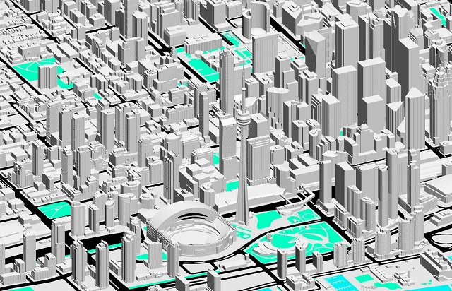
Evidence of this is easy to find. The City of Toronto recently released 3D opendata for use. Such data acts as a foundation to building 3D models that enable spatial modeling and analysis coupled to real-world activities. Most building information modeling (BIM) begins with 3D architectural design and projects oriented toward infrastructure share and collaborate around such models. While countries such as the United Kingdom have now legislated requirements for 3D BIM models, Canada is likely soon to follow.
The recent floods surrounding the Calgary, Alberta region are further evidence that demonstrate a need for high quality, highly accurate 3D geodata. Flood plain modeling and evacuation are highly dependent upon knowing elevations and which transportation and values are at risk. Towards this end, the City of Calgary has been working to create definitive 3D datasets.
The City of Montreal has similarly developed a number of 3D data files oriented to a standard CityGML format in 3D. These files are provided to LOD2 (level-of-detail).
Business and education 3D developments
NGRAIN, a Canadian developer of 3D augmented reality applications has recently formed a partnership with Epson. This partnership is designed to bring 3D augmented reality technology to the wide range of manuals and education products that the company produces.
Applications such as the Canadian Armed Forces Corner Cave Automatic Virtual Environment (Corner CAVE) environment enable “3D reproductions of anything that can be modeled in 3D, such as mechanical sub-components of an engine, a complex weapon system, or a piece of terrain.” Such systems are highly oriented toward the use of geospatial data sets and aerial platforms require high quality 3D topographic models. Recent emphasis on Northern development in Canada will require more terrain modeling and high measurements in those regions as well.
Education in 3D
Serious Labs is an Edmonton, Alberta-based company that specializes in the development of 3D educational materials. This company indicates that students learn faster and more completely when using 3D models and animation educational materials. At the Emily Carr University of Art + Design’s Stereoscopic 3D Centre in Vancouver, these technologies are forming the basis of new educational approaches that heighten student awareness and increase participation. The proximity to 3D game developers, using data that is often generated through 3D geomatics, is also growing.
Something that is not mentioned very often is the need for developing student talent and educating people with respect to 3D and 4D. Under the rubric of geographic education, we can find many spatial activities in Canada, and terms like ‘spatial reasoning’ and ‘spatial skills’. However, this is different than developing a process 3D orientation that is able to move 3D rawly-acquired spatial data into marketable products that demand a higher degree of data-manufacture coupling. There is a rise in the term ‘user design’ across most disciplines today; however, the connection of 3D measurement technology to visualization, modeling and spatial analysis in 3D is not fully developed – although it is in greater demand. This poses a unique opportunity for Canadian industry and geomatics-oriented businesses, particularly with a global export interest.
Opportunity and outlook for 3D in 2015
Canada is poised to quickly adapt to lower energy prices globally that are impacting this industry. 3D and visualization will be used more in large-project design, plan, build and operations because it will help avoid mistakes, ease hand-off of projects, support worker training and education and enable the improved governance of energy projects.
The Canadian building information modeling (BIM) sector is only now beginning to respond more favorably to changes and legislation that is taking place in other nations. Because BIM is 3D oriented, a revised plan for developing Canadian infrastructure in 3D to capitalize on these technologies is needed. This step will suddenly open up Canadian cities and rural areas to new perspectives and viewpoints as 3D augmented reality and visualization technologies enable widespread easy-of-use of complex geomatics data. Does Canada have a 3D infrastructure strategy yet? Such a strategy is not solely about 3D geomatics data capture, but would also include manufacturing elements including prototyping and 3D print models in industry.
A recent Free-Trade Agreement with Europe could offer Canadian companies new opportunities. Consider for a moment that this agreement means 94% of Manitoba’s agricultural products will be eligible to enter the EU duty-free. Those farm producers that employ more 3D-related technology, like UAVs, precision farming, etc. will subsequently reap the benefits of a larger market to 500 million people. High production will become more marketable.
Many of the 3D measurement technologies such as lidar, aerial imagery, and photogrammetry and 3D CAD have been around for a long time. There is an abundance of 3D and visualization data hidden away or stored, because too few people know how to bring it out into the open. There is a unique opportunity here for those willing to develop and grasp new initiatives that would up the game and add value to these technology and data. Understanding 3D processes, spatial analysis in 3D, and modeling through 3D in real-time are just a few examples where strides could lead to new possibilities.
3D data is nice, but analysis and processing of that information and rendering it for use and decision making seems to be the needed step forward. The geomatics and geospatial user is now part of a wider more integrated team walking a path toward transition and change.


Be the first to comment