
A friend of mine who volunteers with a girls’ softball team came to me with a request recently.
“I have the addresses of all of the girls in our softball league”, she said. “I want to see where the girls are coming from. Can you do that GIS magic stuff and put them on the map?”
Until recently, complying with this request would have been difficult to do on my home computer. Although I’m lucky enough to have access to professional quality GIS software at work, I’ve never felt rich enough to pay for such software at home. Nor have I had much interest in installing trial versions of commercial GIS software that always seem to come with exclusions, restrictions, expiry dates, and nagging reminders that make them unattractive to me.
So, in spite of the fact that I like to be helpful and make good use of my GIS skills, I wouldn’t have had any great GIS software readily available if my friend had asked me to do this analysis at the end of last year’s softball season. She, and the girls that she wants to reach, would have been out of luck.
However, because of the advent of QGIS Version 2, I do happen to have some very capable Open Source GIS software on my home computer. I told my friend I’d see what I could do and I fired up QGIS.
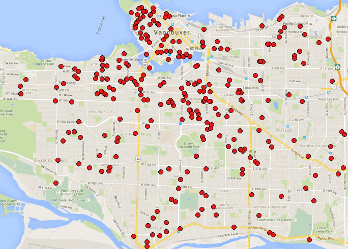
My first step was to geocode the girl’s addresses. Then I put them on the city map as points. Hmm, the result looked interesting, but I didn’t immediately see any strong visual pattern in the data.
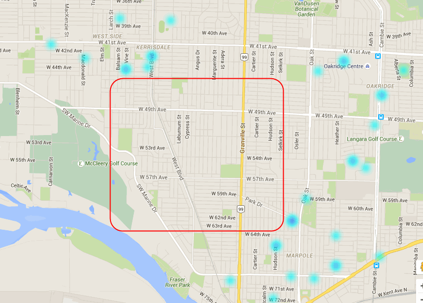
“Wait a minute,” I said to myself, “let me put those points into a heat map.” A heat map output proved to be much better, since it allowed me to see the overall pattern of the addresses. It looks like last season’s Softball players represented most of the city.
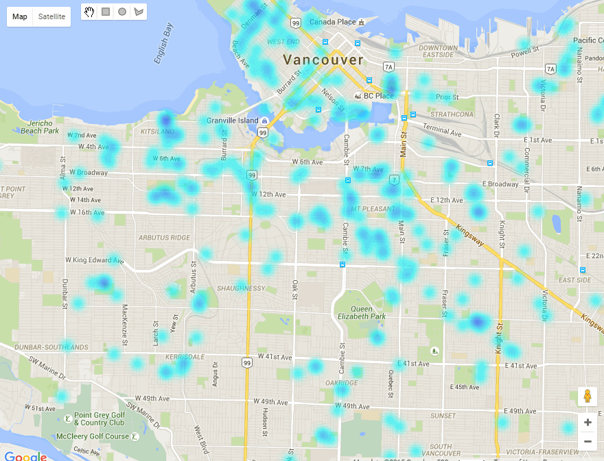
However, a closer examination of the map reveals that there are some areas of the city where there appear to be no addresses. Why is that? This is a question that my friend will have to answer. Now that she can see the patterns revealed by the heat map, she knows where to look.
This illustration throws light on the potential of high-quality Open Source GIS software to provide answers to the non-technical user for many facets of life. I could easily show my friend how to do this type of analysis herself. However, she would probably not be inclined to fork over her money to purchase a high-end GIS product in order to find out where her girls’ homes are clustered.
Having easy access to the software, a necessary step in progressing towards GIS literacy, has been denied to her and many others for many years. To use the softball metaphor, if you can’t get to first base with GIS, you’ll never get home.
But given that QGIS software is free and of high quality, it is now easier for the average person to begin using GIS to perform basic spatial analysis by himself or herself. My friend could easily follow a basic set of instructions for performing this type of analysis, and thus begin the journey of learning more advanced forms of analysis. For example she could try theming the heat map by the age of the girls, thus answering the question “Do girls from different local areas register for softball at different ages?”
The Geographic Information Systems Certificate Program at Langara College utilizes numerous types of Open Source software with the intent of empowering a new generation of GIS users distinct from the typical highly trained GIS specialists who have been the GIS users of the past. The courses offer a combination of technical concepts and hands-on experience with QGIS and other Open Source products, with the aim of teaching students from many backgrounds how to add GIS analysis tools to the arsenal of tools they use in their professional and volunteer activities.
These users can be individuals like my friend, or employees and owners of small businesses or other organizations that haven’t had the cash to put into GIS software, nor the budget to hire a GIS expert. GIS is no longer the esoteric discipline that it once was. Now, because the software is free and does not expire after six months, anyone with average technical abilities can learn basic GIS skills and harness the power of spatial data.
To finish the story about the girls’ softball league, I got the points layer and heat map back to my friend quickly. She was impressed. She said, “That was so easy, you can do this for me every year”. Imagine her reaction when I said to her, “That was so easy, YOU can do this every year.” I then gave her the URL of the Geographic Information Systems Certificate Program. I am looking forward to her hitting her first GIS home run soon.


Be the first to comment