
I often contemplate what it would have been like working at the same job for an entire career. Mind you, the thought of the same job day in and day out never appealed to me. I’m putting down into words the story that is my geomatics journey both in Canada and abroad. Lend me a moment of your time as I paint a picture of my early geomatics education, and my various jobs in both terrestrial and marine geomatics.
Newfoundland: My Canadian Geomatics Education

In 1990 my spirit for outdoor adventure, and fascination with maps and nautical charts, saw me enrolled in Surveying Technology Program at Cabot College. This three-year program, in St. John’s, Newfoundland prepared me for a career in surveying, GIS, cartography, remote sensing, photogrammetry and hydrography.
I graduated in 1993, during an economic downturn, when entry-level jobs in surveying were difficult to find. After struggling to find work and seeing no prospects, I began to think, I needed something else that tied into surveying, and realized spatial information was digital and GIS had a bright future.
I enrolled at Memorial University for a BSc in Geography to pursue a program that I knew would include GIS, cartography, and remote sensing. By 1997, I had a BSc. in geography and I went to work immediately, obtaining a short-term position with Tamarack Geographic’s. There I updated maps of Newfoundland using CARIS GIS software.
CARIS Experience Leads to a Marine Adventure

After my time at Tamarack, my phone was ringing, and on the phone was VP of Nortech Jacques Geosurveys, Inc, requesting an interview. He needed someone with a surveying background that knew CARIS GIS software, and didn’t mind working offshore on a survey ship for various periods of time. I accepted and we began preparing for a massive seafloor mapping survey to the inlet to Voiseys Bay, Labrador, and we would be among the first private survey companies to produce preliminary field sheets to Canadian Hydrographic Service (CHS) standards.
CARIS software is well-known in the hydrographic surveying industry, used by the CHS and many other companies around the world. CARIS is based out of the Maritimes which made it even more interesting to this Canadian.
My time surveying during the summer of 1997 was exciting. Not only were we constructing a nautical chart from infancy, but the team was amazing. We helped each other with challenges, the camaraderie was great, and I thought I could work with this group of people forever. Many of them remain working for Nortech, which is now Fugro GeoSurveys.

After 7 years of marine surveying, being out in all kinds of rough weather, bouncing around offshore Eastern Canada, away from friends and family for extended periods, I knew it was time for a change.
Mining near Millertown, Newfoundland
In the spring of 2004, having a deeper passion for GIS and to get away from the offshore, I slipped into a job with AUR Resources at Duck Pond Mine, located near Millertown, Newfoundland. It felt great working on land, freedom from weeks barred up on a ship. There was a lot to learn, performing QC/QA on a drill hole database, preparing surface and underground geological planning maps using ArcMAP and AutoCAD and other specialized geology programs, such as GEMCOM. Working alongside geologist was easy; they always had a clear picture of what they wanted on a map.
We were in the mine planning stages; everyday presented a new challenge, from compiling historical data and importing new data. By 2006, we were in production, and job satisfaction and salary were my greatest concerns. Once in production, it became a regular routine job I found boring, with what I believed was a low salary for the industry.
Oil exploration in the Gulf of Mexico
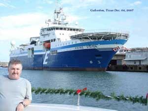
In pursuit of a higher salary, by late 2007 I was working in the Gulf of Mexico as a Navigator with Compagnie Générale de Géophysique (CGG) on 3D Wide-Azimuth marine seismic acquisition. WaZ seismic surveying was a new technology, involving lots of equipment and software to support synchronization of four ships. While learning new equipment and software was interesting, 90 percent of the job involved monitoring multiple GPS navigation acquisition systems. To our dismay the oil price collapsed in 2008, seismic ships were getting stacked, followed by a major layoff at the end of 2009. The oil and gas industry was into a bust phase.
Mineral exploration with Teck Resources
From my connections at Duck Pond Mine, I returned to the mine, which was now owned by Teck Resources. I joined the exploration team to begin mineral exploration, field work, mapping, and databases manipulation. Here I could align my skills and experience while obtaining a lot of job satisfaction.
For those of us in the know. Early 2013 we could see the Duck Pond Mine closure was imminent. I begin quietly networking and contacting head hunters, and potential employers. Being no stranger to career changes and challenges, I had already transitioned from marine surveying into mining. A friend had my résumé which she passed on for an open-pit surveying job. This was to lead to the next phase of my career in geomatics.
Surveying at Mount Milligan, British Columbia
Three months later I was working as a senior surveyor at Mt. Milligan’s open pit gold-copper mine in British Columbia. A mine life span of 25 years felt permanent, if you didn’t mind -30C in January, running around hammering in survey stakes, measuring material moved, and building a massive containment dam. I found an old copy of ArcMap and got to work in my spare time. I was entering the buried and above ground infrastructure to create a GIS that I thought would be useful. This work evolved into our dig permitting system. That system provided maps of the infrastructure and also got out to survey exactly where to expect the pipes or cables. Mine surveying was a permanent comfortable job, until one day, I began to have health issues, ending my career as a mine surveyor!
Career Transition
In the beginning of my career, the challenge was getting experience. Then as I gained experience my focus shifted to earning as much as I could for my retirement. At the end and in later years, job satisfaction became important. Over two decades in the Geomatics field, from marine surveying to mining, the adventure, challenges and learning were always an ongoing event.
Stepping beyond your comfort zone, learning about the industry, studying data, learning hardware and software are important aspects of controlling that career. Fortunately, I am, now in this phase of my geomatics career a die-hard GIS practitioner, and making maps, analyzing spatial data has been a passion for many years, a passion I will continue to pursue.


Be the first to comment