
GoGeomatics Canada had the privilege of interviewing Jessica Coleby, a Research Analyst at InterStractics.
GoGeomatics: Tell us a little bit about yourself. How did your interest in Geomatics start?
Jessica: I currently hold a B.A. in Geographic Analysis and a Master’s of Spatial Analysis from Ryerson University. After graduation I continued my work at a strategic planning consulting firm called InterStratics Consultants Inc. The interest that I have in geomatics started much later than many would guess. It was not until the summer before first year that I even applied to the geographic analysis program. In high school I only took the mandatory geography class and assumed that, that would be the last time that I would have to look at a map for anything beyond directions. After my original plans for university did not go as planned I immediately applied for any programs still accepting applications. When in August I found out that I had been accepted into the geographic analysis program I assumed that it was going to be the longest year of my life before being able to transfer into a program that I really wanted to be in. Needless to say that I did not end up transferring programs but in fact ended up finding a passion that I never thought that I would have.
GoGeomtatics: How are you using Geomatics in your current position?
Jessica: The position I hold currently is of that of a research analyst at a growing strategic planning consulting firm in Toronto. This career allows me to use a wide variety of skills within the geomatics realm based solely on the specific project requirements. In my position, I often use MapInfo to delineate trade areas, analyze customer patterns, and competitors, in order to give the client a better understanding of their business needs, where their strengths are, weaknesses, and improvement areas.
To visit InterStratics’ website click here.
GoGeomatics: What skill types have you gained in this field and are they transferable to other types of industries?
Jessica: In my field, I’ve gained the ability to use statistical analysis. Now I’m able to use functions I didn’t know in the past. I’ve found that these are useful in the sense that due to their broad implementations, I’m able to transfer these abilities to other industries. Such examples are vlookup and countif statements, which makes data disseminating simpler and faster. This not only applies to my field, but others as well. In every project, we first start by doing research, and disseminating those results to create something concrete.
GoGeomatics: Do you have any examples of your past or present GIS work that you are willing to share with us (maps, websites, drawings) and can you provide us a brief explanation?
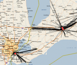
Jessica: This map shows the relationship between a client location and their consumers using a spider graph tool in MapInfo. The map provided an understanding of true trade areas for the client as well as visualizing areas in the market in which potential consumers are being missed. This mapping technique links data based on selected origin and destination files allowing for the understanding of consumer relationships to direct client locations.
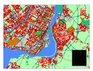
Market share was calculated for a client to allow for a gap analysis of the market. The study was done over the entire client market however, this is an example from the Montreal, Quebec area. The thematic map was created based on market share of the client compared to its direct competitors. The map provides and understanding of the areas in which demand for product is high (Thematic in red scale). The overlay of the land-use provided a more accurate analysis of the market as we allowed for market share to only be visible in residential defined areas. The outcome of this analysis was an understanding of the current consumers purchasing demand allowing for market gaps to be evaluated at a closer level.
GoGeomatics: What do you find rewarding/challenging in your GIS career?
Jessica: I have been given the opportunity to have a career in a field and at a company that is constantly growing and changing. The rewarding aspects of my career is the constant education that I have been able to have. My career has not only provided me the opportunity to make contacts that I never thought I would have but it has allowed me to learn about new techniques, and skills that I will be able to use throughout my career. Challenges that I face constantly lies in data accuracy. That means both ensuring that my reports are accurate, and that the raw data that I use are both correct, and credible. These challenges expose me to the real world situations of geographic consulting. In today’s age, we are bombarded by information from the internet, and other forms of media. Learning to distinguish between what is useful, and what is not is a trait I believe to be important both at work, and in life as a person in general. The challenges I face are just the challenges that I need to face in order to be able to continue in this career and therefore I appreciate the challenges just as much as the rewards.





Be the first to comment