
Looking Back at my First Year, GIS & Geographic Analysis at Ryerson University
After successfully completing my first year at Ryerson University in Toronto, I wanted to share some thoughts about my experiences. I am excited to be joining an industry that is so important, and literally, a down-to-Earth field of study.
At Ryerson my program in Geographic Analysis has three mandatory geography courses in the first year. These courses provided a solid base knowledge which also will serve as a bridge of what I will be diving into later in university. These introductory level courses provided me with the start of what I need to know about the environment, mapping out business success or becoming a GIS Specialist. 
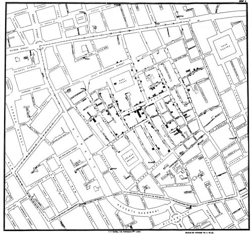
The first geography course I enrolled in during the fall semester was appropriately called “Location, Location, Location” taught by Professor Stephen Swales. The course introduced land use and value, and how the management of the given area can effect society, both in the positive and negative aspects. The significance of location is explained through examples such as: John Snow’s 1854 map of cholera outbreak (See map – right) on Broad Street, the study of businesses when it comes to gravity models and distance decay, and assignments instructing students to examine our own personal neighbourhoods.
In the winter semester, I took arguably an expected course for those fresh out of high school. The course, “Energy, Earth and Ecosystems” had a scientific and systematic learning approach to Physical Geography. The interaction of biotic and abiotic factors on the Earth, along with human intervention taught me and the other students how interconnected our environment is. My professor, Dr. David Atkinson, also shared his research in the Canadian North. Topics of urban ecology, energy transfers and of course climate change were tied together at the end of the term with a field trip to the Port Credit River Watershed.
“Geography and GIS” was taught by Professor Swales, utilizing ArcGIS and MapInfo. Building on the knowledge obtained from his previous course “Location, Location, Location”, I and the other students of my program learned the technical and visual process of GIS, or as many students saw it earlier as, map making. At first learning the basic steps of adding data, understanding geocoding and configuring our maps was our main focus.
In retrospect, my first year in Geographic Analysis has shown me the possibilities for both my potential areas of academic study within geography and after that future career prospects. Both human and physical geography are covered during the first two terms. My first year has really opened up some doors of thought as to where I want to apply myself and geomatics technology. Thanks to the GIS class and Ryerson being the leader in career-focused education, the need for practical learning is incorporated.
My discovery of the GoGeomatics Canada website has allowed me to see into the Canadian geomatics industry and the potential of a career within it I did not have before. By reading the interviews and articles I have seen at least some of the possibilities for myself of job possibilities and where they are located. Also, reading about the future role of geomatics in Canada and the wider world has been useful. I’ve enjoyed and learned much about the debate related to cartography and programming.
Do Programmers Really Make the Best Cartographers?
The Death of Cartography and the Rise of the Machines
I am pumped and looking forward to my second year of Geographic Analysis at Ryerson and the educational, and often entertaining guidance, of GoGeomatics Canada.


Congratulations on your successful year, Edgar.
Hi,
I’m thinking about going for the same programme. Therefore wanted to know about your experience in the next 3 years. Any advice?