||
Technology

International Geospatial Briefing July 12th, 2021: Mapping the hot hotspots in the world; Esri’s book calling for action for conservation; June ArcGIS Living Atlas Updates; Telecomm giant maps climate resilience; Map the graveyards and trace you family tree; LiDAR to stop texting and driving; Digital Twin of the News

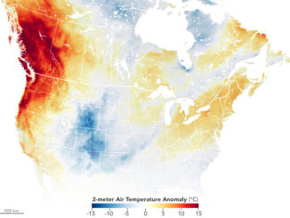
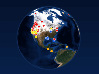
Mapping the hottest temperatures around the world June was an exceptionally hot month for several countries in the northern hemisphere. A “heat dome”, where high pressure traps the heat, is being blamed for the excessively high […]

|||||
Technology

Canadian Geospatial Briefing July 5, 2021: Geospatial Applications for Indigenous Issues; Canadian Company Teledyne CARIS is Mapping the Seafloor; How SBEO is Helping Track Extreme Weather Events from Space; and Agriculture and Agri-Food Canada’s New Drought Forecast Tool

New Applications are Bringing Attention to Important Indigenous Issues June 2021 was a National Indigenous History Month like no other. With the heartbreaking discoveries made at former residential schools across the country, it is crucial […]

|||||
Technology

International Geospatial Briefing June 28th, 2021: Record High Ground Temperatures in Siberia; Digital Divide across the United States; Mapping more than 20% of the Ocean Floor; Tracking Bird Migration; Analysis of Toshka Lakes in Egypt

Ground Temperatures Hit 118 Degrees in the Arctic Circle During the recent heatwave in Siberia ground temperatures reached 118 degrees Fahrenheit (48 degrees Celsius) as seen by satellite imagery. The Copernicus Sentinel satellites were able […]

||||||
Technology

Canadian Geospatial Briefing June 21st, 2021: Apple Maps Cars; Population growth and Housing issues; Elizabeth Cannon’s honorary degree; Saskatchewan’s growing opioid deaths maps; Modernizing COMPSTAT at the Vancouver Police Dept.

Here’s Where Apple Maps Cars are Collecting Images in Canada this Summer Two years ago, a fleet of Apple Maps cars started driving across Canada to improve its own maps. The image below, taken by Jesse […]

|||||
Technology

International Geospatial Briefing June 14th, 2021: Study of Australian Land Ownership; Drone thermal mapping for emergency response; Combination of Digital Twins and GIS; The map of the online world; Vaccine distributions across the world

Australian Land Ownership The ownership of Australian land can be dated back to 60,000 years ago, however, the modern legal system makes the situation more complicated with titles such as freehold, crown leases, native title, […]