• facebook
  • Twitter
  • Linkedin
  • Youtube
  • Linkedin Group
  • Post a Job
  • Post an Ad
  • Post an Event
  • Post a Directory Listing
  • Post a Press Release
  • Media Kit
  • My Account
  • Login
GoGeomatics
  • MAGAZINE
    • BIM & GIS
    • Community
    • Conference news
    • Earth Observation
    • Education & Careers
    • GEOAI
    • Announcements
    • Reality Capture & Lidar
    • Science
    • Technology
  • Directories
    • ASSOCIATION
    • INDUSTRY
    • EDUCATION
    • Open Data
  • EVENTS
    • GeoIgnite Events
    • Events Calendar
    • GoGeomatics Meetups
  • Services
    • Advertising
    • Marketing
    • Post a Job
    • Post an Ad
    • Post an Event
    • Post a Press Release
    • Post a Directory Listing
    • Media Kit
    • Web Design
  • Find a Job
  • Volunteer
    • Start a GoGeomatics Group
    • Editors & Writers Group
  • About Us
    • About Us
    • Contact Us
    • Frequently Asked Questions
  • Videos
Home2020

2020

|||
Technology

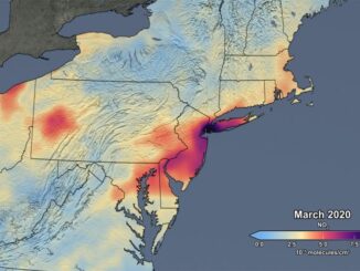
Mapping air pollution: a momentary shift due to COVID-19

28 May 2020 Lindsey Goncalves | 2020

COVID-19 and the resulting economic shutdowns and physical distancing measures have presented us with a peek at what it takes to reduce air pollution and better the world’s air quality. Recent satellite data mapping has […]

|||||
Education & Careers

Student Opportunities with Canadian Cartographic Association

2 March 2020 GoGeomatics Canada | 2020

The Canadian Cartographic Association (CCA) wishes to bring to your attention several opportunities for geospatial students. Every year the CCA announces awards, prizes and scholarships for students involved in various forms of cartography or map-making and […]

|||
Technology

CANADA’S NATIONAL ELEVATION DATA STRATEGY UPDATE

4 December 2019 David Belanger | 2020

November 2019 HRDEM FOR THE ENTIRE CANADIAN ARCTIC! In August, Natural Resources Canada (NRCan) made available a new release of the High Resolution Digital Elevation Model (HRDEM) product for the entire Canadian Arctic! This new 2 m data […]

||||||||||||||||||||||||||||||||||||||||||
Community

2019-2020 Back to School Socials in Pictures – Thank you Sponsors & Participants!

7 November 2019 Jon Murphy | 2019 GoGeomatics

The 6th annual GoGeomatics 2019 Back to School Socials have been a tremendous success.  After coming off the success of GeoIgnite 2019 National Conference in Ottawa. Our groups and group leaders across the country came […]

No Picture
Newsmakers & Press Releases

Canada Takes Part: Arctic Spatial Data Infrastructure Meets in Anchorage

26 July 2016 GoGeomatics Newsmakers | 2014

The Arctic SDI Board, which includes mapping executives from Canada, Kingdom of Denmark, Finland, Iceland, Norway, Russia, Sweden and the United States, recently met in Anchorage, Alaska to further development of a robust Arctic Spatial […]

No Picture
Newsmakers & Press Releases

Global GIS Market to Grow Steadily at a CAGR of More Than 10% by 2020

2 June 2016 GoGeomatics Newsmakers | 2020

Technavios market research analyst predicts the global GIS market to grow steadily at a CAGR of more than 10% by 2020. The ability of geographic information systems (GIS) to enhance the end users productivity, decision-making […]

No Picture
Community

SaveTheMap Campaign: What is the future of geospatial information in India

30 May 2016 Emmanuel Stefanakis | 2016

SaveTheMap Campaign: “to encourage citizens and startups to use geospatial data in everyday lives and create businesses that serve India”   Interesting (geospatial) times in India lately… On May 4th, 2016, just three months after […]

No Picture
Education & Careers

BCIT GIS Survey: should we offer a new type of GIS program?

9 January 2016 Karl Kliparchuk | 2020

The BCIT GIS department is undertaking a needs assessment to determine the feasibility of offering an Advanced Certificate in GIS targeted to individuals who already have a professional degree and career. This Advanced Certificate could […]

Posts pagination

« 1 2 3 4 »

Events

Notice
There are no upcoming events.

View All Events

Services

  • Post a Job
  • Post an Ad
  • Post an Event
  • Post a Directory Listing
  • Post a Press Release
  • Media Kit
  • My Account
  • Login

Jobs

Post a Job
  • Canada Maps and Poster Gallery Volunteer Leads — GeoIgnite 2026
    remote
  • GIS & Data Analytics Lead
    Beaumont, AB
  • Lead Surveyor, Projects/Arpenteur-géomètre principal, projets; arpenteuse-géomètre principale, projets
    North Bay, Thunder Bay
  • Senior GIS Developer
    Calgary, AB
View All Jobs
  • Directories
    • Associations Directory
    • Industry Directory
    • Education Programs
    • Open Data
  • Volunteer
    • Start a GoGeomatics Group
    • Editors & Writers Group
  • About Us
    • GoGeomatics Media Kit
    • Who We Are
    • Contact Us
    • FAQ’s
    • Advertising
    • Marketing
  • Subscribe
GoGeomatics
GoGeomatics is the largest and most popular communications hub promoting the Canadian geospatial community. The business was incorporated in 2011. GoGeomatics hosts over 100 fun, free, location technology networking events each year in cities across Canada.

© 2025 GoGeomatics

  • facebook
  • Twitter
  • Linkedin
  • Youtube
  • Linkedin Group