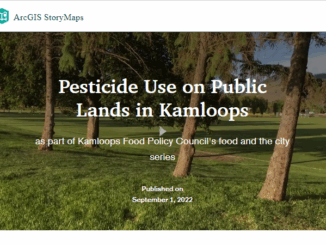
British Columbia
Canadian Geospatial Briefing July 19th, Drone spraying research promising; B.C. wildfire map; Manitoba Infrastructure Projects Map; N.B. COVID dashboard; New database of P.E.I. trails maps
Drone spraying research promising Drone spraying would be ideal for touch-ups and misses in a field after a large sprayer…
Canadian Geospatial Briefing May 10th: Developing Tools to Protect Canada’s Biodiversity; Tracking impact of industrial projects on B.C. species at risk; 3D satellite mapping shows that glaciers are melting faster than ever; Geospatial Maturity Index shows that Calgary is a leader in GIS programs; Community engagement to measure impact of climate change on coastal environments in the Estuary and Gulf of St Lawrence; Surprising locations in Canada that have seen the largest increase in house prices
Carleton and Partners Developing Tools to Protect Canada’s Biodiversity Dr. Joseph Bennett, a biology professor at Carleton University and his…
Post-Wildfire Landscape Metrics & Transition Characteristics in Cariboo Regional District, 2017
The summer of 2017 marked one of the worst fire seasons in British Columbia’s history. By October, wildfires had covered…
COVID-19: Supporting Kamloops, BC businesses using Story Maps
In the middle of March 2020, COVID-19 pandemic leads to social distancing rules in Canada. Public areas such as restaurants…
Your Canadian Geospatial Briefing for June 15th: Canadian Drone delivery solution; City of Montreal open data; Tagged leatherback sea turtles; Endangered Fish in BC
Drone company will convey COVID-19 medical equipment to First Nation Drone Delivery Canada (DDC) will transport COVID-19 medical products using…
2019-2020 Back to School Socials in Pictures – Thank you Sponsors & Participants!
The 6th annual GoGeomatics 2019 Back to School Socials have been a tremendous success. After coming off the success of…
Hatfield releases R-BAM algorithm to all Canadian wildfire agencies
The Rapid Burned Area Mapping (R-BAM) technology was developed over the last three years by Hatfield Consultants and aims to…
Western Division of the Canadian Association of Geographers (WDCAG) Conference
We acknowledge and respect the Lekwungen-speaking peoples on whose traditional territory the University of Victoria stands, and the Songhees, Esquimalt, and …
The New Innovative Master of Geomatics for Environmental Management (MGEM) Program at UBC
This installment of our ongoing series on GIS and education in Canada features GoGeomatics talking to Dr. Trevor Jones, the…
Your Canadian Geospatial Briefing for August 20th: Black Widow Spiders; Sidewalk Labs; BC Wildfires; Back to School Socials
Map of Black Widow Expansion into Canada Scientists are finding evidence of poisonous Black Widow Spiders appearing farther north than…
Karl Kliparchuk talks top GIS Education at BCIT in Vancouver, BC, Canada
GoGeomatics kicks off our series of interview with geospatial program across the country on the West Coast of Canada. We…
Fire GIS Uses Maps, Data, & Social Media–A Hot Tool for BC Residents, Travellers
Every summer in British Columbia, along with long days, sunshine, heat, and little rain comes an all-too-familiar reality: hundreds of…