• facebook
  • Twitter
  • Linkedin
  • Youtube
  • Linkedin Group
  • Post a Job
  • Post an Ad
  • Post an Event
  • Post a Directory Listing
  • Post a Press Release
  • Media Kit
  • My Account
  • Login
GoGeomatics
  • MAGAZINE
    • BIM & GIS
    • Community
    • Conference news
    • Earth Observation
    • Education & Careers
    • GEOAI
    • Announcements
    • Reality Capture & Lidar
    • Science
    • Technology
  • Directories
    • ASSOCIATION
    • INDUSTRY
    • EDUCATION
    • Open Data
  • EVENTS
    • GeoIgnite Events
    • Events Calendar
    • GoGeomatics Meetups
  • Services
    • Advertising
    • Marketing
    • Post a Job
    • Post an Ad
    • Post an Event
    • Post a Press Release
    • Post a Directory Listing
    • Media Kit
    • Web Design
  • Find a Job
  • Volunteer
    • Start a GoGeomatics Group
    • Editors & Writers Group
  • About Us
    • About Us
    • Contact Us
    • Frequently Asked Questions
  • Videos
HomeCanopy

Canopy

||||||||||
Technology

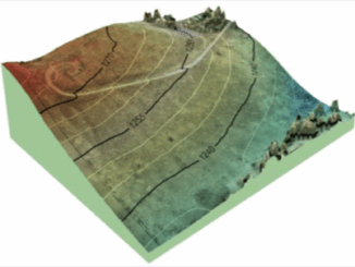
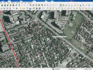
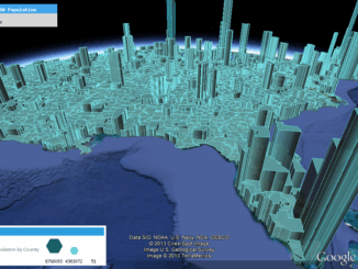
Designing with Information: GIS with Dimension, Ease of Use & Visually Unique

15 July 2013 Edgar Baculi | accuracy

Geomatics and other industries which desire data in accurate yet visually stimulating presentations of communication and information are frequently turning heads at the evolving use of infographics. This inquiry of data and technology fused with […]

UAV Mapping||||||||||||
Education & Careers

Canadian UAV Company Maps Forest Fire Damage in Alberta

8 July 2013 Brent Wanless | 3D

Industry and public awareness for commercial applications of UAV technology has increased significantly in Canada and throughout North America. Initially the technology was primarily developed for military use, where the application requirements are different. Design […]

No Picture
Technology

Microsoft Beta Testing Laserless Point Clouds

24 October 2012 Spencer | 2012

Microsoft Launches Beta Testing Program to Achieve Laserless Point Clouds In July 2012 Microsoft announced the launch of its beta testing program for UltraMap Version 3.0. For those unfamiliar with UltraMap, it is the factory […]

Technology

The Ottawa Tree Canopy Cover Mapping Project

28 September 2012 Regie | 2012

The City of Ottawa Official Plan set a target of 30% tree canopy cover for the entire city. To the author’s knowledge there is no information on the amount of tree canopy for the entire […]

No Picture
Technology

Measuring Tree Canopy Cover in an Urban Environment

2 April 2012 Regie | accuracy

To properly and effectively design and manage the city’s tree canopy it is important to quantify the amount and composition of existing vegetation. Knowing this baseline information provides a benchmark for identifying tree canopy targets […]

Events

Notice
There are no upcoming events.

View All Events

Services

  • Post a Job
  • Post an Ad
  • Post an Event
  • Post a Directory Listing
  • Post a Press Release
  • Media Kit
  • My Account
  • Login

Jobs

Post a Job
  • Canada Maps and Poster Gallery Volunteer Leads — GeoIgnite 2026
    remote
  • GIS & Data Analytics Lead
    Beaumont, AB
  • Lead Surveyor, Projects/Arpenteur-géomètre principal, projets; arpenteuse-géomètre principale, projets
    North Bay, Thunder Bay
  • Senior GIS Developer
    Calgary, AB
View All Jobs
  • Directories
    • Associations Directory
    • Industry Directory
    • Education Programs
    • Open Data
  • Volunteer
    • Start a GoGeomatics Group
    • Editors & Writers Group
  • About Us
    • GoGeomatics Media Kit
    • Who We Are
    • Contact Us
    • FAQ’s
    • Advertising
    • Marketing
  • Subscribe
GoGeomatics
GoGeomatics is the largest and most popular communications hub promoting the Canadian geospatial community. The business was incorporated in 2011. GoGeomatics hosts over 100 fun, free, location technology networking events each year in cities across Canada.

© 2025 GoGeomatics

  • facebook
  • Twitter
  • Linkedin
  • Youtube
  • Linkedin Group