data visualization
Canadian Geospatial Digest January 15, 2024
Remote First Nation Community Getting High-Quality Digital Twin Exploring and Mapping the Environmental Stressors around Wood Buffalo National Park New…
Statistics Canada’s virtual GIS Day
GIS day is a great opportunity for all GIS communities to come together and network. Statistics Canada hosts its second…
A New Stage of GIS Evolution
The GIS market has grown in size every year for the past decade. With a current capitalization of over USD…
GeoIgnite 2020 Video: Digital Transformation – Bilyana Anicic
Bilyana Anicic, the president from Aurora Consulting talks about Digital Transformation on GeoIgnite 2020. In this session, Bilyana sheds light on how we see data in future
Your International Geospatial Briefing for September 14th: Where the GISP’s are; China’s new Earth Observation Sattelite; COVID-19 push to aerial surveying; Interdisciplinary data-driven approach; Interactive historic map that shows your hometown’s location 750 million years ago
A Look at where the GISPs are Dr Dapeng Li, an assistant professor at South Dakota State University, and a…
Géoclip – A geostatistical observatory software product
The Géoclip observatories are web applications for statistical mapping to promote the analysis of territorial data sets. A Géoclip observatory…
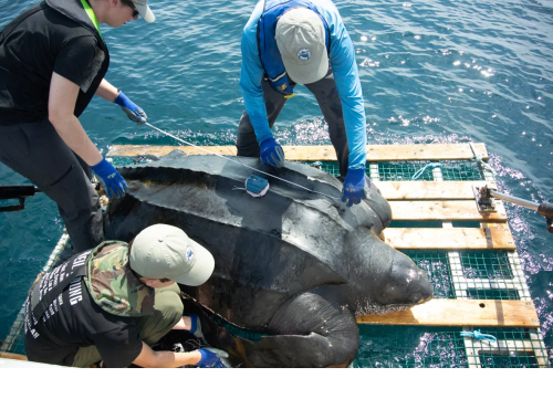
Your Canadian Geospatial Briefing for June 15th: Canadian Drone delivery solution; City of Montreal open data; Tagged leatherback sea turtles; Endangered Fish in BC
Drone company will convey COVID-19 medical equipment to First Nation Drone Delivery Canada (DDC) will transport COVID-19 medical products using…
PCI Geomatics presents free user group meeting on June 17th, 2019, from 1pm-5pm in Ottawa
PCI Geomatics is pleased to announce that we are hosting a free user group meeting on June 17th, 2019, from…
Top Ten Climate Change Maps and GIS Applications
Awareness for climate change has been steadily increasing ever since the Green Revolution in the 1960s. There is a plethora…
Upgrade your Geospatial Skills: leveraging the power of MOOCs
What I want to share with you are some resources related to something called Massive Open Online Course (MOOC) where…
Point, Hub, Link, Node: The Unique Geography of Airports & Pearson
When we go to the airport, do we really ever consider where we’re going? To most of us, even those…
CloverPoint to Showcase Insight(TM) and Latest in Mapping Technology at TECTERRA 2015 Geomatics Show
CloverPoint will be presenting our latest GIS, mapping, and land management solutions used by First Nations, and facility managers at…


