• facebook
  • Twitter
  • Linkedin
  • Youtube
  • Linkedin Group
  • Post a Job
  • Post an Ad
  • Post an Event
  • Post a Directory Listing
  • Post a Press Release
  • Media Kit
  • My Account
  • Login
GoGeomatics
  • MAGAZINE
    • BIM & GIS
    • Community
    • Conference news
    • Earth Observation
    • Education & Careers
    • GEOAI
    • Announcements
    • Reality Capture & Lidar
    • Science
    • Technology
  • Directories
    • ASSOCIATION
    • INDUSTRY
    • EDUCATION
    • Open Data
  • EVENTS
    • GeoIgnite Events
    • Events Calendar
    • GoGeomatics Meetups
  • Services
    • Advertising
    • Marketing
    • Post a Job
    • Post an Ad
    • Post an Event
    • Post a Press Release
    • Post a Directory Listing
    • Media Kit
    • Web Design
  • Find a Job
  • Volunteer
    • Start a GoGeomatics Group
    • Editors & Writers Group
  • About Us
    • About Us
    • Contact Us
    • Frequently Asked Questions
  • Videos
HomeGeoignite2021

Geoignite2021

Community

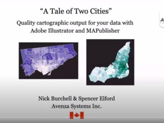
Avenza Quality Cartographic Output For Data With Adobe Illustrator & MAPublisher – GeoIgnite 2021 Talk On YouTube:

23 July 2021 GoGeomatics Canada | adobe illustrator

Adobe Illustrator is not a tool you’d associate with geospatial work, but Avenza is here to show you how to use this software for your cartographic needs! In this talk on Day Three of the […]

|
Community

GIS & Beyond: Smart Software Solutions Made In Poland from GISPartner, GeoIgnite 2021 Talk On YouTube

22 July 2021 GoGeomatics Canada | Bartlomiej Grabowski

Day Three of the GeoIgnite conference featured Gold Sponsor GISPartner. They continue to make waves as a dynamically developing European company, active in field of GIS professional services market in Poland. Their main aim is […]

|||
Technology

INSITE Lifecycle Project Tracker Enables & Delivers Real-Time Data Updates

19 April 2021 Sven Cowan | CMM

When conducting Lidar surveys, efficiency and success are determined to a degree by conditions outside of the surveyors’ control. The best-laid plans can sometimes be delayed by inclement weather conditions, as wind, rain and fog […]

|||
Community

Top 5 Reasons To Attend GeoIgnite 2021

15 April 2021 GoGeomatics Canada | @minerva

GeoIgnite 2021, Canada’s Largest Geospatial conference is just around the corner! This year, the conference is being held online, so everyone can safely participate. If you haven’t gotten your free tickets yet, go register now! […]

|||||
Education & Careers

Sustainable Land Cover And Land Use Monitoring with Satellite Imagery

9 April 2021 Tara O’Shea | Canada

Canada has a population of more than 37.9 million and is growing at a steady pace. Faced with a growing need for space, sustainable management of land cover and land use is critical to protecting […]

Education & Careers

Canadian Market Analysis with POI Data From the AWS Data Exchange

8 April 2021 Hendy Wijaya | @safegraph

SafeGraph’s Canada Core Places (Essential Columns) dataset is available for free in the AWS Data Exchange. To use this POI data to conduct a market analysis, follow the steps below. Getting Started 1. Sign up […]

|||||||
Technology

MAXAR GeoIgnite 2021 Spotlight: Optimizing and Accelerating the Globe in 3D

6 April 2021 Maxar | 3D

Editor’s note: This article is part of a series by Ryan Hamilton, Senior Manager, 3D Products, Maxar Technologies detailing the promise of bringing Maxar and Vricon together as one company. This previous BLOG POST covers the various […]

||||
Technology

Building Software Solutions for Climate Change: Closing the communication gap between citizens and trusted authorities before, during, or after a disaster

19 March 2021 Nicholas Kellet | bigdata

A Climate Change Problem: The Communication Gap between Citizens and Authorities At a time of rising climate change impacts, there is a vital and growing need to prepare for, respond to, and recover from natural […]

Posts pagination

1 2 »

Events

Notice
There are no upcoming events.

View All Events

Services

  • Post a Job
  • Post an Ad
  • Post an Event
  • Post a Directory Listing
  • Post a Press Release
  • Media Kit
  • My Account
  • Login

Jobs

Post a Job
  • Canada Maps and Poster Gallery Volunteer Leads — GeoIgnite 2026
    remote
  • GIS & Data Analytics Lead
    Beaumont, AB
  • Lead Surveyor, Projects/Arpenteur-géomètre principal, projets; arpenteuse-géomètre principale, projets
    North Bay, Thunder Bay
  • Senior GIS Developer
    Calgary, AB
View All Jobs
  • Directories
    • Associations Directory
    • Industry Directory
    • Education Programs
    • Open Data
  • Volunteer
    • Start a GoGeomatics Group
    • Editors & Writers Group
  • About Us
    • GoGeomatics Media Kit
    • Who We Are
    • Contact Us
    • FAQ’s
    • Advertising
    • Marketing
  • Subscribe
GoGeomatics
GoGeomatics is the largest and most popular communications hub promoting the Canadian geospatial community. The business was incorporated in 2011. GoGeomatics hosts over 100 fun, free, location technology networking events each year in cities across Canada.

© 2025 GoGeomatics

  • facebook
  • Twitter
  • Linkedin
  • Youtube
  • Linkedin Group