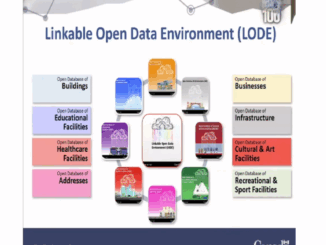
|||||
Technology

International Geospatial Briefing May 17th, 2021: Deepfake geography; the architectural heritage of Mexico City; the problem of space junk; a Female Future in GIS; tracking Coronavirus vaccines; Citizen science – mapping the location of Brood X Cicadas

AI can alter geospatial data to create deepfake geography. Many of us have seen the growing trend of videos of celebrities and politicians saying things they have never really said to warn us of the […]

||
Community

Canadian Geospatial Briefing for November 23rd: Mapping corridors for drones; RAMMS technology to map Lake Huron; Indigenous mapping workshop; InDro Robotics working with Rogers & UBC; 5th Pan-Canadian SDI Summit

Canadian startup AirMatrix maps air corridors for drones AirMatrix is working on mapping out corridors in the sky to create drone “highways”. Manned and unmanned air traffic are becoming more common and creating a model […]