• facebook
  • Twitter
  • Linkedin
  • Youtube
  • Linkedin Group
  • Post a Job
  • Post an Ad
  • Post an Event
  • Post a Directory Listing
  • Post a Press Release
  • Media Kit
  • My Account
  • Login
GoGeomatics
  • MAGAZINE
    • BIM & GIS
    • Community
    • Conference news
    • Earth Observation
    • Education & Careers
    • GEOAI
    • Announcements
    • Reality Capture & Lidar
    • Science
    • Technology
  • Directories
    • ASSOCIATION
    • INDUSTRY
    • EDUCATION
    • Open Data
  • EVENTS
    • GeoIgnite Events
    • Events Calendar
    • GoGeomatics Meetups
  • Services
    • Advertising
    • Marketing
    • Post a Job
    • Post an Ad
    • Post an Event
    • Post a Press Release
    • Post a Directory Listing
    • Media Kit
    • Web Design
  • Find a Job
  • Volunteer
    • Start a GoGeomatics Group
    • Editors & Writers Group
  • About Us
    • About Us
    • Contact Us
    • Frequently Asked Questions
  • Videos
HomeNatural Resources Canada

Natural Resources Canada

Technology

Canadian Geospatial Digest for October 7th, 2024

7 October 2024 Volunteer Editors and Group Writers | 2023 report

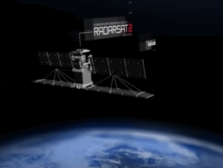
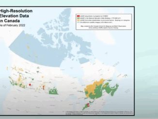
An Era Ends with the Retirement of the Canadian Digital Elevation Model (CDEM) State of the Canadian Space Sector 2023 Autonomous Food Delivery at the Toronto Zoo Uncovering the Legacy of Indigenous Residential Schools through […]

Community

Hydrospatial Advances Program For National Expo Announced

23 July 2024 GoGeomatics Expo | AI

A new program within the expo is the Hydrospatial program.  Here are the first talks announced. More to come! KEYNOTE: Alberta’s Flood Hazard and Fluvial Hazard Identification Initiatives The Government of Alberta’s Flood Hazard Identification […]

Community

FHIMP Invitation for Proposals: Funding Opportunities for Flood Hazard Identification and Mapping Projects

2 January 2024 Farzaneh Farshad | ESRI

Introduction The Flood Hazard Identification and Mapping Program (FHIMP) is a five-year initiative (2023-2028) led by Natural Resources Canada (NRCan) with the goal of enhancing flood preparedness and planning in Canada. This five-year program, spanning […]

Community

Natural Resources Canada (NRCan) Joins the Calgary Geomatics Expo

17 August 2023 GoGeomatics Expo | Archaeology GIS

We are thrilled to announce that Natural Resources Canada will be joining us as an exhibitor and will also be participating in the speaking program at the GoGeomatics Expo, November 6th to 8th, 2023 in […]

|
Community

Federal Government Jobs Showcase & Roundtable Discussion

22 November 2022 GoGeomatics Canada | Canadian Space Agency

GoGeomatics celebrated Geography Awareness Week and GIS day 2022 by hosting a series of talks and webinars. We could not have celebrated Geography week any other way! Canadian Geospatial Workforce Roundtable Discussion: How have work […]

|||||||||
Community

GoGeomatics announces: Geography Awareness Week Program 2022

2 November 2022 GoGeomatics Canada | Canadian Space Agency

GoGeomatics is celebrating Geography Awareness Week and GIS day 2022 by hosting a series of talks and webinars. The first day(17th) is free for everyone wishing to attend online. The second day (19th) is our […]

||||||
Technology

The Federal Government of Canada Geospatial Director’s Panel at GeoIgnite 2022

27 July 2022 GoGeomatics Canada | 2022 Satellite EO Strategy

During the WinterGeo summit this past March, a collection of some of the most prominent names in Canadian Geospatial sciences gathered to address the state of Canada’s geospatial developments, and more importantly, their impact and […]

||||
Technology

NRCAN Leading Initiative to Increase Canada’s Resilience to Flooding

13 May 2022 GoGeomatics Canada | Brian Perry

Geomatic Services Playing Key Role in Initiative On March 1, 2022, Brian Perry, Engineering Advisor for flood modeling with Natural Resources Canada (NRCAN) and Canada’s Centre for Mapping and Earth Observations, spoke during a livestream […]

Posts pagination

« 1 2 3 4 … 9 »

Events

Notice
There are no upcoming events.

View All Events

Services

  • Post a Job
  • Post an Ad
  • Post an Event
  • Post a Directory Listing
  • Post a Press Release
  • Media Kit
  • My Account
  • Login

Jobs

Post a Job
  • Canada Maps and Poster Gallery Volunteer Leads — GeoIgnite 2026
    remote
  • GIS & Data Analytics Lead
    Beaumont, AB
  • Lead Surveyor, Projects/Arpenteur-géomètre principal, projets; arpenteuse-géomètre principale, projets
    North Bay, Thunder Bay
  • Senior GIS Developer
    Calgary, AB
View All Jobs
  • Directories
    • Associations Directory
    • Industry Directory
    • Education Programs
    • Open Data
  • Volunteer
    • Start a GoGeomatics Group
    • Editors & Writers Group
  • About Us
    • GoGeomatics Media Kit
    • Who We Are
    • Contact Us
    • FAQ’s
    • Advertising
    • Marketing
  • Subscribe
GoGeomatics
GoGeomatics is the largest and most popular communications hub promoting the Canadian geospatial community. The business was incorporated in 2011. GoGeomatics hosts over 100 fun, free, location technology networking events each year in cities across Canada.

© 2025 GoGeomatics

  • facebook
  • Twitter
  • Linkedin
  • Youtube
  • Linkedin Group