• facebook
  • Twitter
  • Linkedin
  • Youtube
  • Linkedin Group
  • Post a Job
  • Post an Ad
  • Post an Event
  • Post a Directory Listing
  • Post a Press Release
  • Media Kit
  • My Account
  • Login
GoGeomatics
  • MAGAZINE
    • BIM & GIS
    • Community
    • Conference news
    • Earth Observation
    • Education & Careers
    • GEOAI
    • Announcements
    • Reality Capture & Lidar
    • Science
    • Technology
  • Directories
    • ASSOCIATION
    • INDUSTRY
    • EDUCATION
    • Open Data
  • EVENTS
    • GeoIgnite Events
    • Events Calendar
    • GoGeomatics Meetups
  • Services
    • Advertising
    • Marketing
    • Post a Job
    • Post an Ad
    • Post an Event
    • Post a Press Release
    • Post a Directory Listing
    • Media Kit
    • Web Design
  • Find a Job
  • Volunteer
    • Start a GoGeomatics Group
    • Editors & Writers Group
  • About Us
    • About Us
    • Contact Us
    • Frequently Asked Questions
  • Videos
Homeoffice

office

||
Education & Careers

UAVs in Canada – Key Exposures to Loss and Ways to Protect Yourself

3 October 2016 Association of Ontario Land Surveyors | 2014

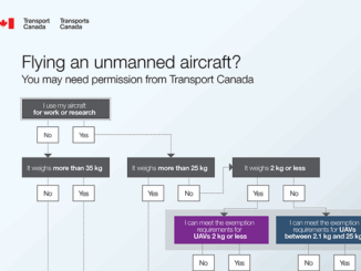
This article was written by Mark Sampson for the Association of Ontario Land Surveyors. Mark’s contact details are at the bottom of the article and here is a direct link. Drones are referred to interchangeably […]

||||
Community

The Importance of Students & Young Professionals in Canada’s Geomatics Community

12 September 2016 GoGeomatics Canada | advice

With the help of our sponsors GoGeomatics Canada is bringing students and young geospatial professionals together at 11 events from coast to coast (Complete list dates & locations is here).  Our September Back to School […]

|
Newsmakers & Press Releases

URISA Heads to Toronto for GIS-Pro 2016

9 September 2016 GoGeomatics Newsmakers | 2016

The Urban and Regional Information Systems Association (URISA), in partnership with its Ontario, Alberta and British Columbia Chapters, is pleased to share the details of GIS-Pro 2016: URISA’s 54th Annual Conference. The event will take […]

|||||
Technology

How Canadian Remote Sensing Was Made Commercially Successful & Exportable

7 September 2016 Robert Ryerson | activity

This piece started as a note on some of my experience as an international consultant in remote sensing specifically and geomatics more generally. But as I looked more and more at the role of consulting, […]

BCIT GIS student project Tetrad||BCIT GIS Student Posters|
Education & Careers

Become a BCIT GIS Student Project / Practicum Sponsor

1 September 2016 Karl Kliparchuk | 2017

The BCIT GIS department has been graduating students for 25+ years.  Our students come from BC, but as well, across Canada and international.  Our program is known to be very demanding, and creates students that […]

||||||
Education & Careers

Using Colour Transparency to Map Election Results

24 August 2016 GIS Program Langara CS | 2012

As the 2016 United States presidential election careens towards its conclusion in November, GIS plays a prominent role in both planning political strategy and in describing the results of the contest. Media outlets create maps and […]

No Picture
Newsmakers & Press Releases

Canadian Institute of Geomatics Expands Executive Team with New VP Dr Brent Hall

16 August 2016 GoGeomatics Newsmakers | 2012

Ottawa, August 16, 2016 – The Canadian Institute of Geomatics (CIG), the largest and most influential geospatial knowledge network in Canada, announced the addition of Dr. Brent Hall as Executive Vice President. Brent will be […]

No Picture
Newsmakers & Press Releases

Countdown to Launch: DigitalGlobe’s WorldView-4 Earth Imaging Satellite

19 July 2016 GoGeomatics Newsmakers | accuracy

Final preparations are underway at Lockheed Martin to ship DigitalGlobe’s WorldView-4 earth imaging satellite to Vandenberg Air Force Base for a Sept. 15 launch. The Lockheed Martin team is completing final satellite testing and checkout […]

Posts pagination

« 1 2 3 4 … 22 »

Events

Notice
There are no upcoming events.

View All Events

Services

  • Post a Job
  • Post an Ad
  • Post an Event
  • Post a Directory Listing
  • Post a Press Release
  • Media Kit
  • My Account
  • Login

Jobs

Post a Job
  • Canada Maps and Poster Gallery Volunteer Leads — GeoIgnite 2026
    remote
  • GIS & Data Analytics Lead
    Beaumont, AB
  • Lead Surveyor, Projects/Arpenteur-géomètre principal, projets; arpenteuse-géomètre principale, projets
    North Bay, Thunder Bay
  • Senior GIS Developer
    Calgary, AB
View All Jobs
  • Directories
    • Associations Directory
    • Industry Directory
    • Education Programs
    • Open Data
  • Volunteer
    • Start a GoGeomatics Group
    • Editors & Writers Group
  • About Us
    • GoGeomatics Media Kit
    • Who We Are
    • Contact Us
    • FAQ’s
    • Advertising
    • Marketing
  • Subscribe
GoGeomatics
GoGeomatics is the largest and most popular communications hub promoting the Canadian geospatial community. The business was incorporated in 2011. GoGeomatics hosts over 100 fun, free, location technology networking events each year in cities across Canada.

© 2025 GoGeomatics

  • facebook
  • Twitter
  • Linkedin
  • Youtube
  • Linkedin Group