Community
Open Data, Open Source, Open Possibilities
Back in 2006 I (Jim) was a student at BCIT and a Vancouver resident, eager to obtain some local data for a project. I sent a hopeful email to City of Vancouver (COV) requesting the […]
Back in 2006 I (Jim) was a student at BCIT and a Vancouver resident, eager to obtain some local data for a project. I sent a hopeful email to City of Vancouver (COV) requesting the […]
Elevation Web Services: Limitations and Prospects Elevation data is necessary for a wide range of geospatial applications such as creating relief maps and rendering 3D visualizations, deriving the slope and aspect of a geographic area, […]

GoGeomatics Kingston first social night was great. We had a much bigger turn-out than expected for our first get together. The group comprised many GIS professionals. We want to thank staff from City of Kingston […]
OTTAWA, Esri Canada User Conference – October 6, 2015 – Parks Canada fosters public understanding, appreciation and enjoyment of Canada’s natural and cultural heritage for present and future generations. The Agency manages national parks, national […]
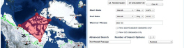
The growing interest in providing open data access has long been integrated into the field of Geomatics. However, the use of Geomatics within open data portals is relatively uncommon. This inclusion provides an interactive and […]

PredictION is an app that provides transit authorities with a unique approach to engage and inform the public. By making use of General Transit Feed Specifications, PredictION will allow users to predict the impacts of […]
Team CODE is made up of myself (Jin Xing), Carl Hughes, and Matthew Tenney. We all come from Roger Tomlinson lab at McGill University. Matthew and I are supervised by Professor Renee Sieber, leader of […]