• facebook
  • Twitter
  • Linkedin
  • Youtube
  • Linkedin Group
  • Post a Job
  • Post an Ad
  • Post an Event
  • Post a Directory Listing
  • Post a Press Release
  • Media Kit
  • My Account
  • Login
GoGeomatics
  • MAGAZINE
    • BIM & GIS
    • Community
    • Conference news
    • Earth Observation
    • Education & Careers
    • GEOAI
    • Announcements
    • Reality Capture & Lidar
    • Science
    • Technology
  • Directories
    • ASSOCIATION
    • INDUSTRY
    • EDUCATION
    • Open Data
  • EVENTS
    • GeoIgnite Events
    • Events Calendar
    • GoGeomatics Meetups
  • Services
    • Advertising
    • Marketing
    • Post a Job
    • Post an Ad
    • Post an Event
    • Post a Press Release
    • Post a Directory Listing
    • Media Kit
    • Web Design
  • Find a Job
  • Volunteer
    • Start a GoGeomatics Group
    • Editors & Writers Group
  • About Us
    • About Us
    • Contact Us
    • Frequently Asked Questions
  • Videos
HomeSurface

Surface

|||||
Technology

Google Earth Engine – What is a Data Cube and Why Canadians Should Care

19 April 2017 Sabina Zaidi | 2012

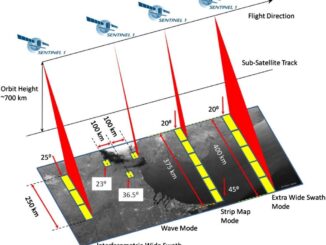
What is a data cube and how is it used for big data analytics?  How does a data cube work with remotely sensed data? Before writing this article I had never heard of a data […]

||||||
Technology

Free Satellite Imagery For You: Sentinel 1 & 2

7 April 2017 Muhammad Luqman | 2017

Sentinel constellations and data products As the ENVISAT program is coming to an end, the European Space Agency has begun the process to develop the Sentinels family of satellites to fulfill the Copernicus earth observation […]

|||Surveying the Joggins Fossil Cliffs|
Education & Careers

COGS NSCC students use Geomatics to explore the history of Black Loyalists & Joggins Fossil Cliff

23 March 2017 Nova Scotia Community College (NSCC) | 2017

NSCC students make major impact in two small communities with huge historical significance Students at Nova Scotia Community College’s Centre of Geographic Sciences are combining their skills in geomatics with a desire to propel the […]

Eastern Canada|||
Education & Careers

Grand Banks to the Gulf of Mexico: My Canadian Geomatics Career

2 March 2017 Jim Strowbridge | 2013

I often contemplate what it would have been like working at the same job for an entire career. Mind you, the thought of the same job day in and day out never appealed to me. I’m […]

||||||
Education & Careers

Geospatial Earth Observation Using Blimps, Balloons and Kites

7 February 2017 Theresa Pinter | 2012

These days drones are all the rage. Nevertheless, there are other ways to collect data from the sky! Blimps, balloons and kites are alternative was to collecting data or remote-sensing imagery. These are great unconventional solutions for […]

||Figure5: iMapBC Start|Cadastral Fabric Definition|Cadastral Fabric Definition|Cadastral Fabric Definition
Community

The Integrated Cadastral Information (ICI) Society and ParcelMap BC

30 January 2017 GIS Program Langara CS | 2016

This is the first of two articles on the release of ParcelMap BC Data, which we see as a significant event in the movement towards Open GIS Data in Canada. This month we’ll cover the […]

Community

The 5 most interesting things that happened in geomatics in 2016

21 December 2016 Florin-Daniel Cioloboc | 2016

Let’s take a step back and have a look at what happened this year. To be honest, it was pretty hard selection. There are way too many things happening at this point around the world. […]

Newsmakers & Press Releases

New Brunswick: CARIS Announces release of HIPS and SIPS™ 10

1 November 2016 GoGeomatics Newsmakers | 2016

Fredericton, NB, Canada – November 01, 2016 – Teledyne CARIS™ is pleased to announce the release of HIPS and SIPS™ 10. This release introduces exciting new capabilities for automation, efficiency, and usability through the integration of […]

Posts pagination

1 2 … 10 »

Events

Notice
There are no upcoming events.

View All Events

Services

  • Post a Job
  • Post an Ad
  • Post an Event
  • Post a Directory Listing
  • Post a Press Release
  • Media Kit
  • My Account
  • Login

Jobs

Post a Job
  • Canada Maps and Poster Gallery Volunteer Leads — GeoIgnite 2026
    remote
  • GIS & Data Analytics Lead
    Beaumont, AB
  • Lead Surveyor, Projects/Arpenteur-géomètre principal, projets; arpenteuse-géomètre principale, projets
    North Bay, Thunder Bay
  • Senior GIS Developer
    Calgary, AB
View All Jobs
  • Directories
    • Associations Directory
    • Industry Directory
    • Education Programs
    • Open Data
  • Volunteer
    • Start a GoGeomatics Group
    • Editors & Writers Group
  • About Us
    • GoGeomatics Media Kit
    • Who We Are
    • Contact Us
    • FAQ’s
    • Advertising
    • Marketing
  • Subscribe
GoGeomatics
GoGeomatics is the largest and most popular communications hub promoting the Canadian geospatial community. The business was incorporated in 2011. GoGeomatics hosts over 100 fun, free, location technology networking events each year in cities across Canada.

© 2025 GoGeomatics

  • facebook
  • Twitter
  • Linkedin
  • Youtube
  • Linkedin Group