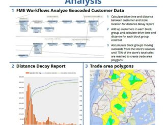
• facebook
  • Twitter
  • Linkedin
  • Youtube
  • Linkedin Group
  • Post a Job
  • Post an Ad
  • Post an Event
  • Post a Directory Listing
  • Post a Press Release
  • Media Kit
  • My Account
  • Login
GoGeomatics
  • MAGAZINE
    • BIM & GIS
    • Community
    • Conference news
    • Earth Observation
    • Education & Careers
    • GEOAI
    • Announcements
    • Reality Capture & Lidar
    • Science
    • Technology
  • Directories
    • ASSOCIATION
    • INDUSTRY
    • EDUCATION
    • Open Data
  • EVENTS
    • GeoIgnite Events
    • Events Calendar
    • GoGeomatics Meetups
  • Services
    • Advertising
    • Marketing
    • Post a Job
    • Post an Ad
    • Post an Event
    • Post a Press Release
    • Post a Directory Listing
    • Media Kit
    • Web Design
  • Find a Job
  • Volunteer
    • Start a GoGeomatics Group
    • Editors & Writers Group
  • About Us
    • About Us
    • Contact Us
    • Frequently Asked Questions
  • Videos
Hometest

test

|
Technology

LiDAR in Canada: Conversation with Dr. Chris Hopkinson Research Chair Remote Sensing University of Lethbridge

6 September 2016 Robert Maher | 3D

The author Bob Maher (BM) and Chris Hopkinson (CH) both worked as scientists at the Appied Geomatics Reearch Group (AGRG) between 2004-2011. Five years later, it was time to catch up. Chris is currently Research […]

BCIT GIS student project Tetrad||BCIT GIS Student Posters|
Education & Careers

Become a BCIT GIS Student Project / Practicum Sponsor

1 September 2016 Karl Kliparchuk | 2017

The BCIT GIS department has been graduating students for 25+ years.  Our students come from BC, but as well, across Canada and international.  Our program is known to be very demanding, and creates students that […]

|A portrait of Jessi Mielke
Education & Careers

Jessi Mielke Esri’s Certification Manager Chats About the Esri Technical Certification Program

29 August 2016 Brian Bancroft | advice

For the last 6 months I’ve been writing articles and discussing my experience in regards to the Esri technical certification program.  You can see a list of my prior articles below. – Esri Technical Certification: […]

||||||
Education & Careers

Using Colour Transparency to Map Election Results

24 August 2016 GIS Program Langara CS | 2012

As the 2016 United States presidential election careens towards its conclusion in November, GIS plays a prominent role in both planning political strategy and in describing the results of the contest. Media outlets create maps and […]

No Picture
Newsmakers & Press Releases

Open Geospatial Consortium adopts the OGC SensorThings API as an official standard

11 August 2016 GoGeomatics Newsmakers | api

The Open Geospatial Consortium (OGC®) has adopted SensorThings API Part 1: Sensing as an official standard. The OGC SensorThings API provides an open, geospatially enabled way to interconnect Internet of Things (IoT) devices, data, and […]

|GIS Ambassador Program|GIS Schools Canada|
Education & Careers

Canadian GIS Ambassador Program: Interview with Brent Hall, Director of Education & Research at Esri Canada

8 August 2016 GoGeomatics Canada | 2015

Interview with Brent Hall, Director of Education and Research at Esri Canada and, along with his staff, the initiator of Esri Canada’s GIS Ambassador program. Dr. Brent Hall is director of Education and Research at […]

No Picture
Newsmakers & Press Releases

RouteMagic: A Unique Way of Mapping Your Bike Route

8 August 2016 GoGeomatics Newsmakers | android

Always at the forefront, the CycleMap application is revolutionising how people plan their bike rides with its RouteMagic, a new and unique feature that, in a matter of seconds, provides customized biking loop path, a […]

||
Education & Careers

The Accidental Geographer: Thoughts on Coming Home

2 August 2016 Robert Maher | 2013

My friend, Edward, directed me towards the Internet and the podcast website entitled ‘The Accidental Geographer’. Edward, in his version of the concept, describes a field trip, where a group of students go into a […]

Posts pagination

« 1 … 4 5 6 … 29 »

Events

Notice
There are no upcoming events.

View All Events

Services

  • Post a Job
  • Post an Ad
  • Post an Event
  • Post a Directory Listing
  • Post a Press Release
  • Media Kit
  • My Account
  • Login

Jobs

Post a Job
  • Canada Maps and Poster Gallery Volunteer Leads — GeoIgnite 2026
    remote
  • GIS & Data Analytics Lead
    Beaumont, AB
  • Lead Surveyor, Projects/Arpenteur-géomètre principal, projets; arpenteuse-géomètre principale, projets
    North Bay, Thunder Bay
  • Senior GIS Developer
    Calgary, AB
View All Jobs
  • Directories
    • Associations Directory
    • Industry Directory
    • Education Programs
    • Open Data
  • Volunteer
    • Start a GoGeomatics Group
    • Editors & Writers Group
  • About Us
    • GoGeomatics Media Kit
    • Who We Are
    • Contact Us
    • FAQ’s
    • Advertising
    • Marketing
  • Subscribe
GoGeomatics
GoGeomatics is the largest and most popular communications hub promoting the Canadian geospatial community. The business was incorporated in 2011. GoGeomatics hosts over 100 fun, free, location technology networking events each year in cities across Canada.

© 2025 GoGeomatics

  • facebook
  • Twitter
  • Linkedin
  • Youtube
  • Linkedin Group