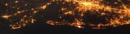
Trees

Canadian Forestry: Landscape Mapping of Whole Tree Inherent Wood Properties

Introduction The forest industry is undergoing a major shift in how it conducts business due mainly from increased competition from…

UAV Mapping

Canadian UAV Company Maps Forest Fire Damage in Alberta

Industry and public awareness for commercial applications of UAV technology has increased significantly in Canada and throughout North America. Initially…

Data and Systems at the Weather Network

In honour of International Women’s day on March 8th, GoGeomatics will feature interviews and articles by women about women in…

The Ottawa Tree Canopy Cover Mapping Project

The City of Ottawa Official Plan set a target of 30% tree canopy cover for the entire city. To the…

Measuring Tree Canopy Cover in an Urban Environment

To properly and effectively design and manage the city’s tree canopy it is important to quantify the amount and composition…

Melanie Tranter – Land Use Specialist at NAV Canada

GoGeomatics Canada had the privilege of interviewing one of their very own editors, Melanie Tranter! GoGeomatics: We would like to begin by…

TECTERRA’s CEO Dr. Mohamed Abousalem: Investing in the Canadian Geomatics Industry

This week GoGeomatics Canada has the privilege of speaking with Dr. Mohamed Abousalem the CEO of TECTERRA. GoGeomatics: Welcome to…

Dr. Robert ‘Bob’ Ryerson: A Canadian Geomatics Perspective on our Industry and Future

GoGeomatics has had the pleasure of speaking with Dr. Robert ‘Bob’ Ryerson of KIM Geomatics Corporation.   Along with his…