Optech Titan wins Grand Award and Award for Technology Innovation at MAPPS 2016

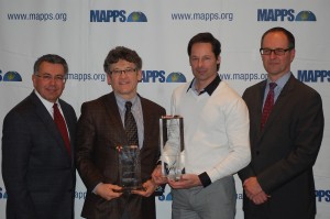
Key Teledyne Optech personnel accept the two awards from MAPPS Executive Director John Palatiello, left. (Image courtesy of MAPPS)
February 9, 2016 — Teledyne Optech is pleased to announce that its Optech Titan multispectral airborne lidar has won both the Grand Award and the Award for Technology Innovation at the 9th Annual MAPPS Geospatial Products and Services Excellence Awards. The judges presented the awards to Teledyne Optech in a ceremony at the MAPPS 2016 Winter Conference in Henderson, NV on February 3rd.
As the world’s first commercial multispectral lidar, the Titan impressed judges by using three channels at different wavelengths to open up brand-new applications for lidar surveying, including automated target classification. By merging the point clouds from all three lidar channels (532, 1064, and 1550 nm), surveyors can now determine the relative reflectance of targets along each wavelength. Teledyne Optech’s partners have already developed algorithms for differentiating soil, asphalt, grass, trees, and buildings using Titan’s multispectral data, and have even identified trees by their genus.
The judges also noted that the Titan gives surveyors the flexibility to handle topographic and bathymetric surveying with the same sensor, unlike single-channel lidar systems, which force operators to choose either land or water surveying. In a single flight, operators can efficiently survey topography from high altitude using the Titan’s infrared (1064 and 1550 nm) channels, then use its green (532 nm) channel to survey shallow coastal and inland waters at depths down to 22 meters.
Finally, the judges were impressed by the Titan sensor head’s compact design, which contains an embedded medium-format digital camera for collecting co-aligned imagery, and fits in a standard 16” gyro-stabilized mount to improve efficiency and data quality.
“Teledyne Optech’s ALTM Titan is a marvel in lidar engineering,” said Robert “Bob” Burtch, PS, CP, Professor Emeritus at Ferris State University in Big Rapids, Michigan, and chairman of the panel of judges. “This development allows the collection of bathymetric lidar, topographic lidar and multispectral lidar in one single sensor.”
“We are very proud to have the Titan acknowledged for its innovative design and revolutionary new applications,” said Michel Stanier, Chief Operating Officer at Teledyne Optech. “We have led the lidar industry for over 40 years, and these awards confirm our place on the cutting edge of lidar development.”
Find out more at www.teledyneoptech.com.
About Teledyne Optech
Teledyne Optech is the world leader in high-accuracy lidar 3D survey systems, integrated cameras, and productivity-enhancing workflows. With operations and staff worldwide, Teledyne Optech offers both standalone and fully integrated lidar and camera solutions for airborne mapping, airborne lidar bathymetry, mobile mapping, terrestrial laser scanning, mine cavity monitoring, and industrial process control, as well as space-proven sensors. Teledyne Optech supports its clients with an around-the-clock team, on-site service, and regular efficiency enhancements to the workflow of its integrated systems. Accuracy and productivity matter!
For further information, please contact your Regional Sales Manager or:
Wayne Szameitat
International Sales Manager
Teledyne Optech
300 Interchange Way
Vaughan, Ontario, Canada L4K 5Z8
+1 905 660 0808
inquiries@teledyneoptech.com
www.teledyneoptech.com


A revolution in remote sensing is beginning. We’ll be hearing more about multispectral lidar.