
Data acquisition is without a doubt one of the most important processes in the implementation of any GIS. As GIS professionals, it is imperative that we have access to and work only with spatial information that is accurate and correct. Not doing so can cause delays, affect the budget of the project, and in some cases even damage the reputation of otherwise respectable companies.
In the age of the Internet, acquiring any information has become easier than ever. GIS professionals can gain access to various spatial datasets from multiple sources just by doing a Google search. For this reason, it is important to question the integrity of the data we are using. I have lost count of how many times I identified GIS datasets containing wrong or inaccurate information. I also have lost count of how many times I chose to build my own GIS datasets to ensure the integrity and quality of my spatial data.
Although GIS is relatively new as a discipline, the challenge of acquiring accurate spatial information has been around for centuries. As early as the beginning of the nineteenth century, it is possible to observe the development of accurate standards in geography with the foundation of national geographic societies, such as the Société de Géographie de Paris, in 1821, and the Royal Geographic Society of London, in 1830. One of the concerns about professional standards that emerged during this period was finding reliable spatial information to be used in cartography.
Why bring the past to a contemporary discussion about the importance of data integrity in a GIS? The answer is simple. GIS professionals and cartographers from the past are connected through the mutual concern of finding and using the most accurate and reliable spatial information. In this article, I explain how being connected to some of the finest travel writers, surveyors, and explorers, enabled a cartographer from the eighteenth century to leave a legacy that has outlived his existence.
1. VERNER, ARROWSMITH, TURNOR, COOK, HEARNE…
The late Professor Coolie Verner (1917-1979), known for his pioneering work in adult education and his contributions to the University of British Columbia (UBC), wrote extensively about the history of cartography. One of the common topics Professor Verner lectured about was the Arrowsmith firm. The Arrowsmith firm was a map publishing company established in London and founded by the cartographer Aaron Arrowsmith in 1786. Aaron Arrowsmith was a talented cartographer intimately familiar with the science of projection, who possessed unusual skills and ingenuity in collecting spatial information from a variety of sources. He was considered the best cartographer of his time, and his firm was famous for producing the most accurate and comprehensive maps available in London. Among Aaron Arrowsmith’s most meaningful contributions to the cartography of the eighteenth century is his 1795 map of North America, which at the time possessed the most comprehensive information of North America available in the world. But how did Arrowsmith, an eighteenth-century cartographer residing in London, obtain reliable spatial information for this map? It is known from sources, such as Verner (1971) and Hayes (2006), that Arrowsmith was connected to and relied on travel writers and their travel accounts to obtain the spatial information that he used to create maps. Among these travel writers, as Derek Hayes observes in his study Historical Atlas of Canada, published in Vancouver, British Columbia, in 2006, is the surveyor Phillip Turnor. His descriptions of North America provided cartographers such as Arrowsmith with valuable material to be employed in cartography.
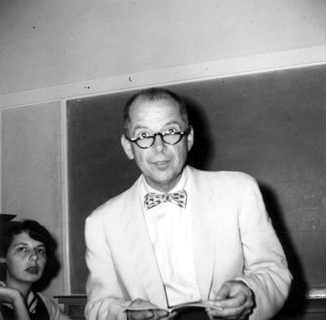
Prof. Coolie Verner in a classroom (Source: UBC Archives Photograph Collection)
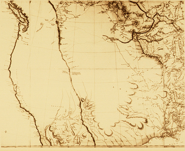
Arrowsmith’s 1795 Map of North America (Source: Wikimedia Commons)
2. EXPLORING THE SOUTH OF THE BORDER: KOSTER
In my personal work, I have outlined how the Arrowsmith firm went global by producing maps of not only North America, but also of South America. The travel writer Henry Koster, famous for his travel account Travels in Brazil (published originally in London in 1816), assisted Arrowsmith and his firm just like Phillip Turnor did. I posit that British explorers of North America, such as Turnor, and of South America, such as Koster, while occupying different spheres of exploration, were equally important to Arrowsmith’s work. The outline of Aaron Arrowsmith’s renowned map of the world from 1808 was published in Koster’s original 1816 account. Koster’s concern with the accuracy of Arrowsmith’s descriptions, however, caused him to modify and add changes to Arrowsmith’s original map. As Koster wrote, “the outline of the map is taken from Mr. Arrowsmith’s large map of South America; and the names and situations of some places are corrected, and others are inserted from my own knowledge.” Arrowsmith’s 1808 map, entitled “Map of the world on a globular projection, exhibiting particularly the research of Captain James Cook,” is divided into 24 sections. One of these sections is the South American section mentioned by Koster. This section is incomplete and contains names of places that are incorrect. Koster corrected the spelling of many of these names, such as Pernambuco (spelled in the map as Pharnamboquo) and Recife (spelled in the map as Recif) and added a number of unknown places that he discovered to Arrowsmith’s original map.
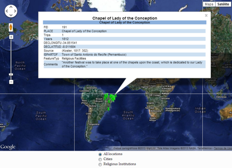
Interactive web application depicting the places identified by Koster in Brazil
Koster’s findings enabled the Arrowsmith firm to correct the misspelled names in the 1817 edition of the same map, as well as to create a map of Brazil in 1832 containing all of the places accurately identified by Koster in Northeast Brazil. I am currently building a web application using ArcGIS 10 and Google Maps that enables users to interact with each place Koster wrote about (http://www.andersonsandes.com/koster/).
3. SO WHAT IS THERE TO BE LEARNED?
Space has always shaped important human, social, and economic events. The rise of GIS as a discipline, the multibillion-dollar industry it has created, and its use by organizations and enterprises to conduct their businesses and expand their markets, show that we rely on spatial information just as we did in the past. With the rise of an economy based on digital technologies, we have never been as connected and never had so much access to information –including spatial information– as in the present. For our businesses and organizations to triumph, though, we have to show the same care that cartographers and travel writers did with the spatial information they used in their travel accounts and maps. Questioning our GIS datasets, investigating how accurate and reliable they are, and even deciding to create a GIS dataset from scratch are just as important as learning the programming language of the latest mobile technology. We will not get much out of a GIS if our spatial information is not accurate and reliable, and we may do a disservice to our enterprises and to our clients if the most important thing in a GIS, the geographic information, is inaccurate or used inappropriately.
REFERENCES AND FURTHER READING
Arrowsmith, Aaron. Result of Astronomical Observations in the Interior Parts of North America. London: C. Buckton, 1794.
Hayes, Derek. Historical Atlas of the North Pacific Ocean: Maps of Discovery and Scientific Exploration, 1500-2000. Vancouver: Douglas & McIntyre, 2001.
____________. Historical Atlas of Canada: Canada’s History Illustrated with Maps. Vancouver: Douglas & McIntyre, 2006.
Koster, Henry. Travels in Brazil: In the Years from 1809 to 1815. London: Longman, Hurst, Rees, Orme and Brown, 1816.
Owens, J. B., “Toward a Geographically-integrated, Connected World History: Employing Geographic Information Systems (GIS).” History Compass, 5, 6 (2007): 2014-2040, 10.1111/j.1478-0542.2007.00476.x.
Sandes, Anderson C. “British Travel Accounts and Maps: Henry Koster and the Making of Space in Nineteenth-Century Brazil.” MA Thesis, Idaho State University, 2010.
Verner, Coolie. “The Arrowsmith Firm and the Cartography of Canada.” The Canadian Cartographer 8, no. 1 (1971): 1-7.


Be the first to comment