
That is the role of the OGC Canada Forum.
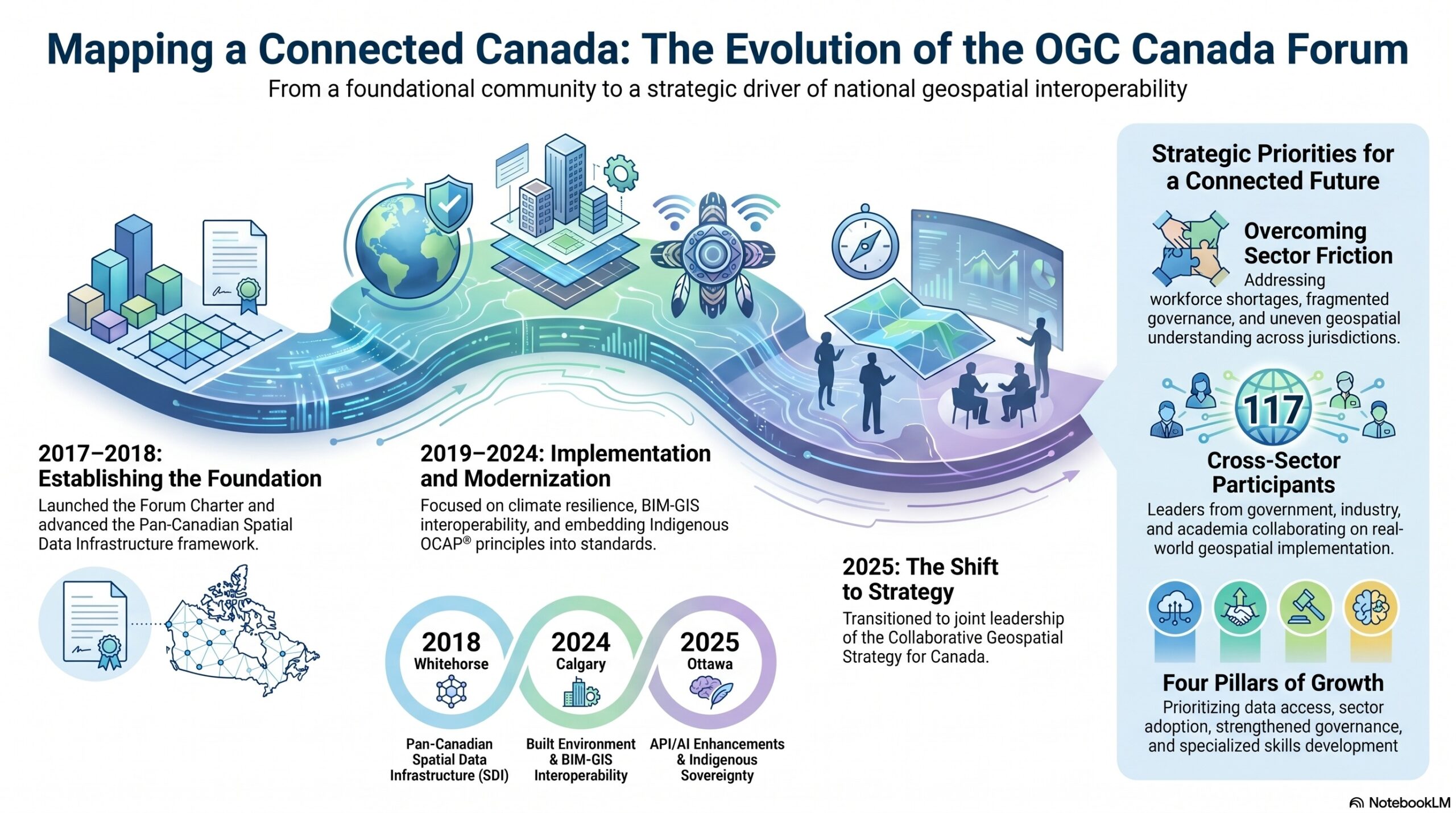
Founded in 2017, the OGC Canada Forum brings together government, industry, Indigenous communities, and academia to address a practical challenge: how to make geospatial data easier to share, understand, and use across Canada. It serves as a neutral, open platform where the community can work through real interoperability and data challenges, aligning around common approaches, shared standards, and real-world implementation. Sessions have been held across the country, alongside a growing number of virtual engagements.
![]()
![]()
Over time, each session has built on the last:
- St. John’s (2017): The inaugural Canadian OGC Summit brought together public, private, academic, and Indigenous leaders to establish the Forum Charter and founding co-chairs. It also highlighted early innovations such as MapML and the SensorThings API as building blocks for national interoperability.
- Whitehorse (2018): In partnership with the Canadian Council on Geomatics (CCOG), the Forum advanced the concept of a Pan-Canadian Spatial Data Infrastructure, with a focus on data sharing, disaster management, and supporting provincial, territorial, Indigenous and community level needs within a common framework.
- Banff (2019): At the 112th OGC Technical Committee, the focus shifted to implementation. Working sessions produced a coordinated national work plan covering standards-based innovation, climate resilience, disaster response, and Arctic and coastal monitoring.
- Montréal (2024): Re-engaging in person after COVID, the Forum marked a reset; reaffirming its role while advancing SDI modernization, addressing the relevance of standards in the age of AI, and embedding Indigenous sovereignty and Ownership, Control, Access and Possession (OCAP®) principles into the national conversation.
- Calgary (2024): Attention turned to the built environment, with a focus on Building Information Modelling (BIM)-GIS interoperability, climate and infrastructure resilience, and the formation of the National Council for the Digitization of Canada’s Built Environment (NCD-CBE) to support coordinated governance and adoption of standards such as ISO 19650.
- Ottawa (2025): Most recently, the Forum advanced discussions on SDI modernization, BIM-GIS convergence, and enhancements to GEO.ca using modern APIs and AI, while reinforcing the importance of Indigenous sovereignty, sustainable funding, and cross-sector collaboration.
From Conversation to Strategy
Over the past several years, the work of the Forum has moved from convening conversations to shaping national direction through joint leadership. That shift became clear in September 2025, when the Forum supported a pan-Canadian conversation on the Collaborative Geospatial Strategy for Canada, facilitated by the CCOG. The session brought together 117 participants from across government, industry, academia, and Indigenous organizations—not to discuss theory, but to reflect on what is actually happening on the ground.
What emerged was direct and practical. The challenges were familiar to anyone working in the sector: workforce shortages, fragmented governance, and a lack of coordination across jurisdictions. At the same time, geospatial capability remains unevenly understood outside specialist communities, limiting broader adoption and impact.
But the conversation did not stop at identifying problems. Participants pointed to clear, actionable steps to move forward together: modernizing metadata, improving guidance for adoption, and making geospatial tools easier to use in everyday decision-making. From that, a set of shared priorities began to take shape: improving access to data, increasing adoption across sectors, strengthening infrastructure and governance, and building the skills needed to support future growth.
This is not a theoretical roadmap. It reflects the direction the community is already moving toward and where alignment is beginning to take hold.
Why This Matters Now
Geospatial data is no longer a niche capability. It sits at the center of climate response, infrastructure planning, natural resource management, and national security. The demand is not just for more data, but for data that can be trusted, shared, and applied across systems.
Yet the underlying challenge remains. Data exists. Standards exist. Technology exists. The difficulty is making them work together consistently, at scale, and across jurisdictions that operate differently.
That is where the Forum continues to focus its effort: reducing friction, aligning approaches, and helping systems connect in ways that are practical and repeatable. The goal is not to introduce new complexity, but to make what already exists work better together.
From Strategy to Action
Attend the OGC Canada Forum at GeoIgnite 2026
The OGC Canada Forum takes place on Monday, May 11 in Ottawa as part of GeoIgnite 2026.
Participation is open both in person in Ottawa and virtually online.
This session focuses on how Canada moves from geospatial strategy to implementation, aligning standards, infrastructure, and investment across jurisdictions.
→ Register for the OGC Canada Forum
Monday, May 11 | 1:00 PM to 4:00 PM | Includes the featured session
“Why Mapping is So Hard”
The next step is to move from direction to implementation.
The OGC Canada Forum returns to GeoIgnite in Ottawa on May 11 with that focus in mind. The session will bring together government, Indigenous organizations, industry, and academia to work through how these priorities are applied in practice—how standards support real-world systems, how interoperability is implemented across jurisdictions, and where coordination is needed to move faster.
The intent is straightforward: not to produce another report, but to align around what comes next and how to move forward together.

Be Part of the Work
The OGC Canada Forum is open and collaborative by design. Participation spans the full spectrum—from students and practitioners to senior leaders shaping national policy—but the expectation is the same: contribute to the work shaping the future of geospatial in Canada, together.
That means bringing real use cases, identifying gaps, and helping define how systems should operate in practice. If you are working with geospatial data in Canada, this is a place to engage, connect, and help shape what comes next.
The Forum looks forward to seeing you in Ottawa this May 11.


Be the first to comment