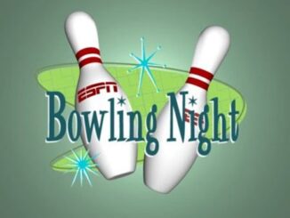
• facebook
  • Twitter
  • Linkedin
  • Youtube
  • Linkedin Group
  • Post a Job
  • Post an Ad
  • Post an Event
  • Post a Directory Listing
  • Post a Press Release
  • Media Kit
  • My Account
  • Login
GoGeomatics
  • MAGAZINE
    • BIM & GIS
    • Community
    • Conference news
    • Earth Observation
    • Education & Careers
    • GEOAI
    • Announcements
    • Reality Capture & Lidar
    • Science
    • Technology
  • Directories
    • ASSOCIATION
    • INDUSTRY
    • EDUCATION
    • Open Data
  • EVENTS
    • GeoIgnite Events
    • Events Calendar
    • GoGeomatics Meetups
  • Services
    • Advertising
    • Marketing
    • Post a Job
    • Post an Ad
    • Post an Event
    • Post a Press Release
    • Post a Directory Listing
    • Media Kit
    • Web Design
  • Find a Job
  • Volunteer
    • Start a GoGeomatics Group
    • Editors & Writers Group
  • About Us
    • About Us
    • Contact Us
    • Frequently Asked Questions
  • Videos
Home2017

2017

|
Community

City of Peterborough Mapping Talk – February 21 GoGeomatics Social

1 February 2017 GoGeomatics Canada | 2017

Tuesday, February 21, 2017 – 6:30 PM One Eighty Hunter Street 180 hunter street, Peterborough, ON This month we have a very special guest speaker joining us.  Juliana Pentikainen, GIS Technologist at City of Peterborough, will […]

||Figure5: iMapBC Start|Cadastral Fabric Definition|Cadastral Fabric Definition|Cadastral Fabric Definition
Community

The Integrated Cadastral Information (ICI) Society and ParcelMap BC

30 January 2017 GIS Program Langara CS | 2016

This is the first of two articles on the release of ParcelMap BC Data, which we see as a significant event in the movement towards Open GIS Data in Canada. This month we’ll cover the […]

High Resolution Mapping Along the Coastal Zone - https://geomatics.one
Newsmakers & Press Releases

Atlantic Canada: COGS: Geomatics Professionals Coming to Discuss High Resolution Coastal Mapping

30 January 2017 GoGeomatics Newsmakers | 2017

High Resolution Coastal Zone Mapping This collaborative effort by GANS & the CIG will engage the geospatial community & increase awareness on the value that geospatial data provides to effective decision making January 30, 2017 (Halifax, NS) – Next week […]

Newsmakers & Press Releases

Toronto 2017: 6th Annual York Geomatics Career Fair

23 January 2017 GoGeomatics Newsmakers | 2017

It’s quite amazing to see the kind of foundation that a few students can create with a goal in mind. Over the last 6 years, the Geomatics Club At York University has done so. Our […]

Technology

Marine Geomatics Primer: Using UUVs to Take Flight Underwater

20 January 2017 Elaha Akrami | 2012

Unmanned Underwater Vehicles One of the most interesting things to happen in regards to marine geomatics technology has been the development of advanced Unmanned Underwater Vehicles (UUVs). Think of the UUV as the underwater counterpart […]

Community

GIS in Public Health: Kingston GoGeomatics Social Thursday, January 19

16 January 2017 GoGeomatics Canada | 2017

Free GIS & Public Health  Talk in Kingston Thursday, January 19, 2017 6:00 PM Sir John A Public House 343 King Street E, Kingston, ON   Brian Mosley GISP is a GIS Analyst with KFL&A […]

No Picture
Technology

Canadian Geomatics Innovation: Ecere Develops a Next Generation GIS

11 January 2017 Ozair Khan | 2014

Not many companies undertake the ambitious goal of creating a new geospatial software suite from scratch. Ecere, a Canadian company based in Gatineau, Québec has been developing a software platform that has positioned them to […]

Newsmakers & Press Releases

Feb 7-8: Two Day Workshop on High Resolution Mapping Along Coastal Zones

6 January 2017 GoGeomatics Newsmakers | 2016

The coastal zone, that dynamic geographic region where the interaction of the sea and land occurs, is vital to the lifestyle and economy of Atlantic Canada. Having quality geospatial data is essential for mapping coastal […]

Posts pagination

« 1 … 7 8 9 … 11 »

Events

Notice
There are no upcoming events.

View All Events

Services

  • Post a Job
  • Post an Ad
  • Post an Event
  • Post a Directory Listing
  • Post a Press Release
  • Media Kit
  • My Account
  • Login

Jobs

Post a Job
  • Canada Maps and Poster Gallery Volunteer Leads — GeoIgnite 2026
    remote
  • Software Engineer – Geographic Information System (GIS)
    Ottawa, ON
  • GIS Data Quality Analyst
    Burnaby, British Columbia
  • GIS Cartographer
    Montreal, QC
View All Jobs
  • Directories
    • Associations Directory
    • Industry Directory
    • Education Programs
    • Open Data
  • Volunteer
    • Start a GoGeomatics Group
    • Editors & Writers Group
  • About Us
    • GoGeomatics Media Kit
    • Who We Are
    • Contact Us
    • FAQ’s
    • Advertising
    • Marketing
  • Subscribe
GoGeomatics
GoGeomatics is the largest and most popular communications hub promoting the Canadian geospatial community. The business was incorporated in 2011. GoGeomatics hosts over 100 fun, free, location technology networking events each year in cities across Canada.

© 2025 GoGeomatics

  • facebook
  • Twitter
  • Linkedin
  • Youtube
  • Linkedin Group