• facebook
  • Twitter
  • Linkedin
  • Youtube
  • Linkedin Group
  • Post a Job
  • Post an Ad
  • Post an Event
  • Post a Directory Listing
  • Post a Press Release
  • Media Kit
  • My Account
  • Login
GoGeomatics
  • MAGAZINE
    • BIM & GIS
    • Community
    • Conference news
    • Earth Observation
    • Education & Careers
    • GEOAI
    • Announcements
    • Reality Capture & Lidar
    • Science
    • Technology
  • Directories
    • ASSOCIATION
    • INDUSTRY
    • EDUCATION
    • Open Data
  • EVENTS
    • GeoIgnite Events
    • Events Calendar
    • GoGeomatics Meetups
  • Services
    • Advertising
    • Marketing
    • Post a Job
    • Post an Ad
    • Post an Event
    • Post a Press Release
    • Post a Directory Listing
    • Media Kit
    • Web Design
  • Find a Job
  • Volunteer
    • Start a GoGeomatics Group
    • Editors & Writers Group
  • About Us
    • About Us
    • Contact Us
    • Frequently Asked Questions
  • Videos
HomeBC

BC

|||||||||
Technology

Fire GIS Uses Maps, Data, & Social Media–A Hot Tool for BC Residents, Travellers

8 August 2017 Dianne Gray | ArcGIS Online

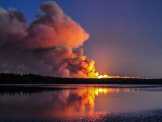
Every summer in British Columbia, along with long days, sunshine, heat, and little rain comes an all-too-familiar reality: hundreds of wildfires. Some of them affect only uninhabited regions in BC, but many threaten communities, property, […]

|||||||||||||||
Technology

Using Swipe Maps to View Wildfire Destruction in BC

31 July 2017 GIS Program Langara CS | BC

On July 7, 2017 a series of devastating wildfires began in the Cariboo region of British Columbia. The effects of these wildfires will take much time and many resources to make recovery. GIS can have […]

||
Newsmakers & Press Releases

May 5: Vancouver: NRCan Discovery Centre Science Open House

1 May 2017 GoGeomatics Newsmakers | 2017

Come talk to scientists in Canada’s oldest science agency at a Canada 150 Open House.  Visitors can check out over ten information booths on volcanoes, minerals in everyday life, paleontology, and ancient tsunamis, all part […]

URISA BC|
Newsmakers & Press Releases

URISA BC – Engage: Make It So With GIS in Community Engagement

27 April 2017 GoGeomatics Newsmakers | 2017

What: Engage: Make It So With GIS in Community Engagement Where: Vancouver, BC When: Thursday, 15 June 2017 from 8:00 AM to 5:00 PM (PDT) From private companies to municipal and national governments, from parents […]

Thunder Bay
Community

New GoGeomatics Group in Thunder Bay, Ontario

24 March 2017 Jon Murphy | 2017

GoGeomatics is excited to introduce the Thunder Bay GoGeomatics group as the newest grass roots effort by local geospatial professionals, students, and organizations to get together and network in Canada. Over the last 7 years […]

|
Newsmakers & Press Releases

Canadian Hydrographic & National Surveyors Conferences: 2018 Victoria, BC: March 26-29

20 March 2017 GoGeomatics Newsmakers | 2018

2018 Canadian Hydrographic & National Surveyors Conferences  March 26-29, 2018, Victoria B.C. Sponsor and Exhibitor Registration is now opened.  You are invited to partner with the Canadian Hydrographic Association and the Association of Canada Lands […]

|
Newsmakers & Press Releases

URISA BC: Vancouver Call for Presentations on GIS Trends in Community Engagement

13 March 2017 GoGeomatics Newsmakers | 2017

Call for Presentations Following the success of our December event, the URISA BC Executive Team is busy planning our next seminar for the Vancouver Marriott Pinnacle Downtown. Join us in mid-June, 2017 for URISA BC’s […]

||BC Pinot Noir Map enlarged section|BC Pinot Noir Map
Technology

GIS in Action: How Does BC Pinot Noir Express Terroir?

8 March 2017 Karl Kliparchuk | 2012

Editors note: In this previously published article, Karl Kliparchuk, BCIT GIS Program Head & Instructor uses GIS to explore the aromas and flavors of wine from British Columbia, Canada. We are breaking down BC wine […]

Posts pagination

« 1 2 3 4 … 19 »

Events

Notice
There are no upcoming events.

View All Events

Services

  • Post a Job
  • Post an Ad
  • Post an Event
  • Post a Directory Listing
  • Post a Press Release
  • Media Kit
  • My Account
  • Login

Jobs

Post a Job
  • Canada Maps and Poster Gallery Volunteer Leads — GeoIgnite 2026
    remote
  • GIS & Data Analytics Lead
    Beaumont, AB
  • Lead Surveyor, Projects/Arpenteur-géomètre principal, projets; arpenteuse-géomètre principale, projets
    North Bay, Thunder Bay
  • Senior GIS Developer
    Calgary, AB
View All Jobs
  • Directories
    • Associations Directory
    • Industry Directory
    • Education Programs
    • Open Data
  • Volunteer
    • Start a GoGeomatics Group
    • Editors & Writers Group
  • About Us
    • GoGeomatics Media Kit
    • Who We Are
    • Contact Us
    • FAQ’s
    • Advertising
    • Marketing
  • Subscribe
GoGeomatics
GoGeomatics is the largest and most popular communications hub promoting the Canadian geospatial community. The business was incorporated in 2011. GoGeomatics hosts over 100 fun, free, location technology networking events each year in cities across Canada.

© 2025 GoGeomatics

  • facebook
  • Twitter
  • Linkedin
  • Youtube
  • Linkedin Group