• facebook
  • Twitter
  • Linkedin
  • Youtube
  • Linkedin Group
  • Post a Job
  • Post an Ad
  • Post an Event
  • Post a Directory Listing
  • Post a Press Release
  • Media Kit
  • My Account
  • Login
GoGeomatics
  • MAGAZINE
    • BIM & GIS
    • Community
    • Conference news
    • Earth Observation
    • Education & Careers
    • GEOAI
    • Announcements
    • Reality Capture & Lidar
    • Science
    • Technology
  • Directories
    • ASSOCIATION
    • INDUSTRY
    • EDUCATION
    • Open Data
  • EVENTS
    • GeoIgnite Events
    • Events Calendar
    • GoGeomatics Meetups
  • Services
    • Advertising
    • Marketing
    • Post a Job
    • Post an Ad
    • Post an Event
    • Post a Press Release
    • Post a Directory Listing
    • Media Kit
    • Web Design
  • Find a Job
  • Volunteer
    • Start a GoGeomatics Group
    • Editors & Writers Group
  • About Us
    • About Us
    • Contact Us
    • Frequently Asked Questions
  • Videos
HomeLIS

LIS

|||||||||||||||||||||
Education & Careers

My COGS GIS Education

9 March 2017 Richard Davenport | 2014

What About COGS The Centre of Geographic Sciences (COGS) is one of the best colleges in Canada for learning GIS.  As a COGS graduate myself I am writing this article to help future students make […]

|
Newsmakers & Press Releases

Toronto & Calgary: Federal Floodplain Mapping Workshop March 28th & 30th

9 March 2017 GoGeomatics Newsmakers | 2017

The Federal Floodplain Mapping Guidelines workshop, hosted by Canadian Water Resources Association (CWRA) on behalf of the Government of Canada, has been arranged in order to present and gather input regarding the recently developed Federal […]

||BC Pinot Noir Map enlarged section|BC Pinot Noir Map
Technology

GIS in Action: How Does BC Pinot Noir Express Terroir?

8 March 2017 Karl Kliparchuk | 2012

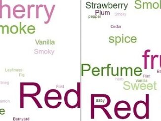
Editors note: In this previously published article, Karl Kliparchuk, BCIT GIS Program Head & Instructor uses GIS to explore the aromas and flavors of wine from British Columbia, Canada. We are breaking down BC wine […]

No Picture
Community

Top Ten Climate Change Maps and GIS Applications

7 March 2017 Priscilla Ancinelli | agriculture

Awareness for climate change has been steadily increasing ever since the Green Revolution in the 1960s. There is a plethora of data, maps, and Geographic Information Systems (GIS) applications available freely or accessible to the […]

||||
Technology

GNOSIS – A New Geomatics Software Suite

27 February 2017 Ozair Khan | 3D

Creating a new GIS from scratch is a tough undertaking. It involves a lot of innovation. Ecere, a Canadian company based in Gatineau, Québec has been developing a software platform that has positioned them to […]

No Picture
Technology

Esri Canada Community Maps Program: Why more communities need to take advantage of this

20 February 2017 Shivam Vyas | analysis

The Community Maps Program (CMP) was introduced by Esri Canada in 2009 allowing organizations to share and host geographic data.  The CMP is accessible to public and private organizations and web users.  The platform for […]

Newsmakers & Press Releases

Call for Papers: CAG: Critical Geographies of Migration

13 February 2017 GoGeomatics Newsmakers | 2017

Please consider submitting an abstract for the CAG 2017 York University, May 29 – June 2, 2017. The last day to submit abstracts for either special or general paper sessions via the conference website is February 24, 2017. […]

|||||
Education & Careers

Interview with Sam Scovill, GIS Technician and 3 Day Champion on Jeopardy

3 February 2017 Sabina Zaidi | 2013

Every weeknight, my mom and I watch Jeopardy together. Jeopardy always starts with the announcement of the contestants by their profession.  Usually we hear about the doctors, the lawyers and the teachers on Jeopardy. But […]

Posts pagination

« 1 … 3 4 5 … 65 »

Events

Notice
There are no upcoming events.

View All Events

Services

  • Post a Job
  • Post an Ad
  • Post an Event
  • Post a Directory Listing
  • Post a Press Release
  • Media Kit
  • My Account
  • Login

Jobs

Post a Job
  • Canada Maps and Poster Gallery Volunteer Leads — GeoIgnite 2026
    remote
  • Software Engineer – Geographic Information System (GIS)
    Ottawa, ON
  • GIS Data Quality Analyst
    Burnaby, British Columbia
  • GIS Cartographer
    Montreal, QC
View All Jobs
  • Directories
    • Associations Directory
    • Industry Directory
    • Education Programs
    • Open Data
  • Volunteer
    • Start a GoGeomatics Group
    • Editors & Writers Group
  • About Us
    • GoGeomatics Media Kit
    • Who We Are
    • Contact Us
    • FAQ’s
    • Advertising
    • Marketing
  • Subscribe
GoGeomatics
GoGeomatics is the largest and most popular communications hub promoting the Canadian geospatial community. The business was incorporated in 2011. GoGeomatics hosts over 100 fun, free, location technology networking events each year in cities across Canada.

© 2025 GoGeomatics

  • facebook
  • Twitter
  • Linkedin
  • Youtube
  • Linkedin Group