• facebook
  • Twitter
  • Linkedin
  • Youtube
  • Linkedin Group
  • Post a Job
  • Post an Ad
  • Post an Event
  • Post a Directory Listing
  • Post a Press Release
  • Media Kit
  • My Account
  • Login
GoGeomatics
  • MAGAZINE
    • BIM & GIS
    • Community
    • Conference news
    • Earth Observation
    • Education & Careers
    • GEOAI
    • Announcements
    • Reality Capture & Lidar
    • Science
    • Technology
  • Directories
    • ASSOCIATION
    • INDUSTRY
    • EDUCATION
    • Open Data
  • EVENTS
    • GeoIgnite Events
    • Events Calendar
    • GoGeomatics Meetups
  • Services
    • Advertising
    • Marketing
    • Post a Job
    • Post an Ad
    • Post an Event
    • Post a Press Release
    • Post a Directory Listing
    • Media Kit
    • Web Design
  • Find a Job
  • Volunteer
    • Start a GoGeomatics Group
    • Editors & Writers Group
  • About Us
    • About Us
    • Contact Us
    • Frequently Asked Questions
  • Videos
Homeorthophotos

orthophotos

|||||
Technology

High Resolution Remote Sensing Supports Victoria International Airport’s Operations

10 February 2023 Kenneth Ang | airports

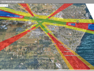
Introduction In a recent project for Victoria International Airport (YYJ), Terra Remote Sensing Inc (TRSI) acquired high resolution photogrammetry and LiDAR data sets. These were acquired at 2cm resolution for the imagery and 30 points […]

||||
Technology

Canadian Geospatial Briefing November 22nd, 2022

21 November 2022 GoGeomatics Canada | 2021 B.C Wildfire

AI aims to prevent a repeat of 2004 Peterborough flood City of Medicine Hat Wins 2022 ESRI special achievement in GIS award TCS, UofT team up with plan to create ‘urban data sets’ for smart […]

||||
Technology

Share your Maps & Data: Soar.Earth jazzes up free access to satellite content every day

18 March 2021 Paul Yeung | atlas

Geared towards the general public, Soar.Earth presents an online platform that resembles a digital, free-of-charge atlas. Pooling in from crowd-sourced content, including satellite imagery, hobbyist drone photos and environmental remote sensing data, it almost feels […]

No Picture
Technology

Canadian Geomatics Innovation: Ecere Develops a Next Generation GIS

11 January 2017 Ozair Khan | 2014

Not many companies undertake the ambitious goal of creating a new geospatial software suite from scratch. Ecere, a Canadian company based in Gatineau, Québec has been developing a software platform that has positioned them to […]

No Picture
Newsmakers & Press Releases

eyesMap3D: The most accurate and powerful 3D photo modeling software

11 May 2016 GoGeomatics Newsmakers | 2015

Global based technology company eCapture announced today the launch of its versatile and intuitive software eyesMap3D, to generate accurate 3D models and point clouds, which measure directly from images. What are the benefits of using […]

|
Community

BCIT Program Has the GIS Talent You Need

28 August 2015 Karl Kliparchuk | 2014

The BCIT GIS department has been graduating students for 25+ years.  Our students come from BC, but as well, across Canada and international.  Our program is known to be very demanding, and creates students that […]

Robert E Lee|George Meade|Lutheran Seminary|Lutheran Seminary with Union Line
Education & Careers

Gettysburg: What Could Lee See?

29 July 2014 Bert V. de Bruijn | aerial

In an age devoid of modern communications methods and digital maps, military generals often made tactical decisions based on what they could see with their own eyes. In studying the Battle of Gettysburg, many people […]

No Picture
Technology

Evaluation of the Service New Brunswick Geographic Data & Maps Section

18 February 2013 Marcus Hinds | aerial

Service New Brunswick  (SNB)  is serving up geospatial data to the community so lets have look at what they are doing.  The portal allows access to all provincial services including, Service New Brunswick locations, employment […]

Posts pagination

1 2 »

Events

Notice
There are no upcoming events.

View All Events

Services

  • Post a Job
  • Post an Ad
  • Post an Event
  • Post a Directory Listing
  • Post a Press Release
  • Media Kit
  • My Account
  • Login

Jobs

Post a Job
  • Canada Maps and Poster Gallery Volunteer Leads — GeoIgnite 2026
    remote
  • GIS & Data Analytics Lead
    Beaumont, AB
  • Lead Surveyor, Projects/Arpenteur-géomètre principal, projets; arpenteuse-géomètre principale, projets
    North Bay, Thunder Bay
  • Senior GIS Developer
    Calgary, AB
View All Jobs
  • Directories
    • Associations Directory
    • Industry Directory
    • Education Programs
    • Open Data
  • Volunteer
    • Start a GoGeomatics Group
    • Editors & Writers Group
  • About Us
    • GoGeomatics Media Kit
    • Who We Are
    • Contact Us
    • FAQ’s
    • Advertising
    • Marketing
  • Subscribe
GoGeomatics
GoGeomatics is the largest and most popular communications hub promoting the Canadian geospatial community. The business was incorporated in 2011. GoGeomatics hosts over 100 fun, free, location technology networking events each year in cities across Canada.

© 2025 GoGeomatics

  • facebook
  • Twitter
  • Linkedin
  • Youtube
  • Linkedin Group