

Map of Black Widow Expansion into Canada
Scientists are finding evidence of poisonous Black Widow Spiders appearing farther north than ever before. Citizens with smartphones have been snapping photos of the spiders and helping to track their emergence in Southern Ontario and Quebec. Citizen science apps like Bugguide and iNaturalist are providing data to Yifu Wang at the University of Cambridge (who was the lead author on a study tracking Black Widows during her undergraduate degree at McGill). Yang’s report states that climate change “could be a strong contributor to the increase in occurrences of northern black widow beyond their historical northern limit.”
2018 GoGeomatics Back to School Social dates, venues & first sponsors announced 

The end of summer is in sight, and geospatial professionals across Canada are getting ready to gather for the biggest event of the year: The GoGeomatics Back to School Social! Dates, venues, and our first Gold and Silver sponsors have been announced on the GoGeomatics website. Sponsorship opportunities are still available; contact us through the form below to find out more and download our 2018 Back to School GoGeomatics Sponsorship Brochure.
Sidewalk Labs plans for Toronto Waterfront smart city
Google affiliate Sidewalk Labs has shared its ideas for a proposed smart city development on Toronto’s Quayside Waterfront neighbourhood. The development comprises a collection of mid-rise buildings, narrow, walkable streets, roads that change colour (due to a surface made of movable, snow-melting hexagon-shaped tiles), and expansive public spaces. Sidewalk Labs and Waterfront Toronto have been in talks for months to release the plans for the futuristic, pedestrian-focused development and green spaces. Sensors will collect data on movement and interactions, but costs and details on how the technology will operate have yet to be announced.
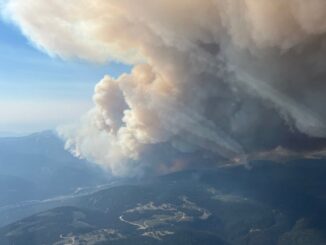
Topic: Wildfire maps BC Canada

Extreme fire danger resulted in the declaration of a state of emergency lasting 14 days in British Columbia on Wednesday, August 15th. Almost 20,000 people have so far been impacted by 566 wildfires burning in the region. Around 47 of the fires are large enough to be a threat to public safety and contributed to an air quality advisory in parts of Oregon as smoke drifted south to the United States. The federal government has promised to deploy aid through aircraft, and Mexico, New Zealand and Australia have also offered to assist in firefighting efforts.


Be the first to comment