
Flooding is Canada’s most financially devastating natural disaster, causing extensive damage to communities, infrastructure, and ecosystems. Despite the importance of flood hazard maps for understanding and mitigating risks, many areas in Canada lack up-to-date maps, making proactive flood management efforts challenging. Recognizing this gap, Natural Resources Canada (NRCan) has been leading the Flood Hazard Identification and Mapping Program (FHIMP) since 2021, in collaboration with Environment and Climate Change Canada and Public Safety Canada. This initiative aims to improve flood hazard mapping and enhance resilience by leveraging modern geospatial technologies, particularly airborne lidar data.
At LidarCANEX 2025, David Belanger, Project Manager at NRCan, and Charles Papasodoro, Project Leader at NRCan, provided an overview of Canada’s flood risk landscape. The premier B2B online forum held on January 29, 2025, brought together experts in Lidar and reality capture with practicing 3D professionals from Canada and beyond.
LidarCANEX is Canada’s premier annual event focused on the latest advancements in Lidar technology. Hosted virtually, the event brings together experts, professionals, and innovators in the geospatial industry to explore new techniques, tools, and trends that are shaping the future of Lidar and geospatial data. From AI-driven mapping to its applications in various industries, LidarCANEX serves as an essential platform for learning, networking, and discovering the cutting-edge of Lidar technology.
Belanger and Papasodoro highlighted the role of Lidar data in flood modelling, hazard mapping, and decision-making for flood management. Their presentation covered the objectives of the National Elevation Data Strategy, the FHIMP’s progress, and the future of Lidar-based flood mapping in Canada.
The Role of the National Elevation Data Strategy
The National Elevation Data Strategy was established in 2015 to address the urgent need for high-resolution, accurate, and up-to-date elevation data in Canada. Prior to its inception, national elevation data were inconsistent, often outdated, and lacked the resolution required for effective flood modeling.
Key Goals of the Strategy:
- Make accurate, high-resolution digital elevation data accessible to the public and government agencies.
- Ensure a nationally consistent and seamless dataset for flood risk assessment and other geospatial applications.
- Support federal priorities by enhancing geospatial infrastructure for climate change adaptation, infrastructure planning, and emergency response.
Why Flood Mapping is Critical for Canada
Floods pose a $2.9 billion annual risk to Canada’s economy, yet studies indicate that only 6% of Canadians living in flood-prone areas are aware of their risk. Many communities lack access to up-to-date flood hazard maps, limiting their ability to prepare for and mitigate flood damage effectively.
Challenges in Flood Hazard Mapping:
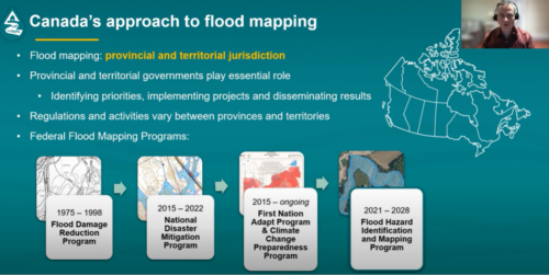
- Many existing maps date back to the 1970s, making them obsolete in today’s changing climate conditions.
- Provinces and territories have varying approaches to flood mapping, creating inconsistencies in data availability.
- Flood risk assessment requires high-resolution elevation data, which was previously unavailable at a national scale.
How Lidar Improves Flood Mapping:
Lidar technology offers an advanced, highly precise method for mapping flood-prone areas by:
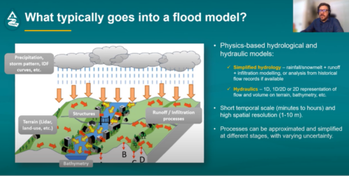
- Providing detailed elevation models that improve the accuracy of flood simulations.
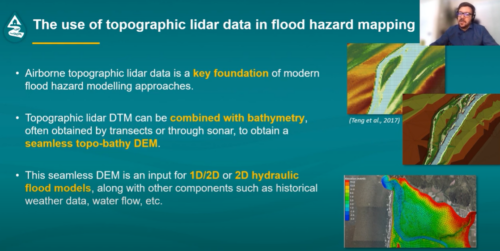
- Penetrating vegetation and water bodies to generate seamless topographic and bathymetric models.
- Supporting hydrological and hydraulic modeling for better flood predictions.
Lidar Data Acquisition and FHIMP’s Progress
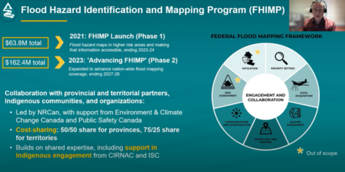
Since 2021, the FHIMP has been driving national flood mapping efforts, funding 59 Lidar data acquisition projects covering 253,000 km². These datasets serve as foundational inputs for flood mapping and are being progressively integrated into national elevation products.
Key Milestones of FHIMP:
- Over 1.6 million sq km of Lidar data already integrated into national elevation datasets.
- Projected coverage of 3 million sq km by 2028.
- 75% of the cost of Lidar acquisition in the territories is covered by the federal government.
Lidar Data for Flood Management:
NRCan uses topo-bathymetric Lidar to create seamless elevation models of floodplains, improving the accuracy of flood simulations. This data is essential for modeling storm surges, riverine flooding, and infrastructure vulnerabilities.
“We created the National Elevation Data Strategy because there was a need for high-resolution, accurate, and up-to-date elevation data. Before this strategy, national elevation products did not meet the needs of flood modeling, and the data was often outdated,” said David Belanger.
“Lidar data acquisition is one of the most critical aspects of flood mapping. With Lidar-derived terrain models, we can more accurately model how water flows, which is essential for understanding flood risks and developing effective mitigation plans,” added Charles Papasodoro.
Future Directions and National Collaboration
The FHIMP is a collaborative initiative involving federal, provincial, and municipal governments, as well as private sector stakeholders. Looking ahead, NRCan aims to:
- Expand Lidar acquisition efforts to include higher-risk flood zones.
- Develop AI-enhanced Lidar classification models to automate flood hazard mapping.
- Enhance public access to flood hazard maps via a centralized national portal.
The Role of Lidar in Regional Flood Modeling
- Quebec, New Brunswick, and PEI have near-complete regional flood mapping coverage.
- Multi-watershed modeling is being tested to bridge the gap between national flood models and local hazard assessments.
LidarCANEX 2026
If you are a Lidar enthusiast or want to learn more, join us for LidarCANEX 2026 and keep an eye on the website: https://lidarcanex.com/.
And here is the sign-up form to get more information for LidarCANEX 2026 in your inbox.
Thank You to Our Sponsors


Be the first to comment