COGS NSCC students use Geomatics to explore the history of Black Loyalists & Joggins Fossil Cliff
NSCC students make major impact in two small communities with huge historical significance
Students at Nova Scotia Community College’s Centre of Geographic Sciences are combining their skills in geomatics with a desire to propel the province’s economy forward.
Student researchers Tristan Marvin and Scott MacDonald have each designed projects that will impact two small Nova Scotian communities with huge historical significance: Joggins and North Preston.
In April 2017, Tristan Marvin (Diploma Geographic Sciences – Remote Sensing Concentration) will conduct a laser scan and UAV survey of the Joggins Fossil Cliffs—a UNESCO World Heritage site.
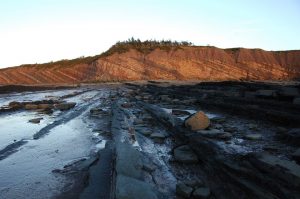
The Joggins Fossil Cliffs are a world-recognized, representative site of the Carboniferous Period in Geologic history. The cliffs contain “an unrivalled fossil record preserved in its environmental context.”[1] The site is located on the shores of the Bay of Fundy—home to the world’s highest tides. Because of this, coastal erosion is a major issue in the area.
“As the cliffs erode, new fossils are exposed, but the rate is changing over time,” says Tristan. “This research will help better forecast how the cliffs might look in the future and inspire people to make long-terms decisions to address the effects of man-made climate change.”
Tristan has partnered with the College’s Applied Geomatics Research Group (AGRG)—led by Dr. Timothy Webster. Tristan will be adding to research conducted by the AGRG over the last decade.
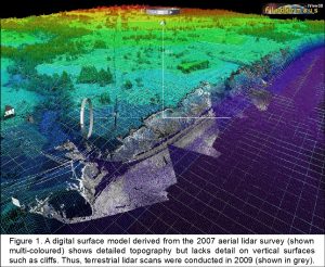
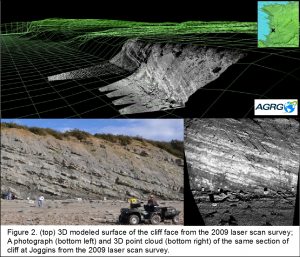
In 2007, Tim and his team conducted an aerial lidar survey of the Joggins Fossil Cliffs. The survey resulted in detailed models of the topography in the area, but fewer details on vertical cliff faces (Fig. 1). In 2009, the AGRG conducted a follow-up survey – a 3D laser scan along roughly 800 metres of cliff faces at Joggins – to obtain better measurements. This resulted in a 3D modeled surface of the cliff face (Fig. 2).
In April, Tristan and several other student researchers from AGRG will again survey the cliffs, this time using two remote surveying platforms. This is a similar method to that used in 2009; however, it will be more advanced with the addition of a 3D mobile laser scanner mounted on an all-terrain vehicle (ATV), and a sophisticated unmanned-aerial vehicle (UAV) mounted with a high quality camera.
Tristan will also construct a new 3D-modeled surface of the cliff face. This will be compared to the modeled surface from the 2009 baseline AGRG survey.
The results will provide an assessment of how much, if any, the Joggins Fossil Cliffs have eroded in the past eight years as well as any accretion that may have taken place. The research will be used to support the ongoing management and conservation of the site.
“If we can educate the industry leaders of tomorrow by inspiring preventative action and highlighting opportunities here in the province, we won’t just decrease the impact of erosion, we can inspire an economic result too.”
For more information on the cliffs at Joggins, Nova Scotia, please visit the Joggins Fossil Institute.
Fighting for the African Nova Scotian residents of North Preston
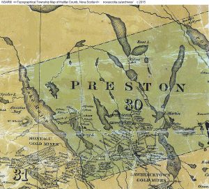
As some of Nova Scotia’s first settlers, Black Loyalists were offered plots of land in exchange for their support during the American Revolutionary War—and again during the War of 1812—in an area of the province known today as North Preston. However, the Loyalists were not issued deeds or land titles for those plots.
Today, approximately one-third of North Preston’s properties remain un-deeded to those who occupy the land. This has been the case for over 200 years.
As the years have passed, many property boundaries have merged, new homes have been erected on the space between properties, and vegetation has left many boundary markers lost.
Remedying the situation for one property can cost upwards of $10,000 and require years of effort on the part of residents, lawyers, and surveyors; therefore, little progress has been made since the 1990’s.
Scott MacDonald (Geomatics Engineering Technology) is using his surveying skills to help.
“Many retired surveyors have volunteered to survey the land, but the equipment isn’t something that an individual owns,” says Scott. “You also have to be a legal surveyor to sign off on the work. This excludes many people.”
Scott explains that this is a legally complicated scenario, which requires coordination between lawyers, surveyors, the Department of Natural Resources, and members of the community—each having a small, but necessary, part to play. Until recently, the surveying community largely was not involved. Scott feels that this is the last necessary piece to fall into place.
North Preston has five outdated control monuments that are hindering surveying from moving forward. While Nova Scotia has officially made the switch to North American Datum of 1983 (NAD 83) as its geodetic reference system—much like the rest of Canada, the United States, Mexico, and Central America—many control monuments still use Average Terrestrial System 1977 (ATS 77). This includes those located in North Preston.
In April 2017, Scott and a team of fellow students will begin the process of updating the control monuments to NAD 83 using a Leica Real Time Kinematic (RTK). Work will take place under the supervision of veteran legal surveyor Walter Jackson (retired), and be reported to Jason Bond, coordinate controller for the Nova Scotia Coordinate Reference System.
With conversion from ATS 77 to NAD 83, the survey of properties can proceed.
Once the monuments are updated, Scott and his fellow students will establish control on five identified properties, and survey those properties via traditional total station traverse. The new survey data will be combined with historical data to reestablish old boundaries, and draw new property lines. When complete, the resulting survey data will be submitted to the Nova Scotia Barristers’ Society, where seven lawyers are providing pro-bono land claim support to North Preston residents.
“I’m hopeful that this is the last ingredient needed to take care of things,” says Scott. “Now, through NSCC, the Nova Scotia Department of Natural Resources and with the support of Walter, it may.”
For more information on the North Preston Land Recovery Initiative, please visit Untitled: The Legacy of Land in North Preston.
[1] Joggins Fossil Cliffs website, 2017. http://www.jogginsfossilcliffs.net/cliffs/


