
- US Signals Potential Changes at NOAA
- UConn Researchers Tracking Change in Precious Ecosystems
- New UN Report Offers Insights into how Geospatial Technology can Advance Global Food Security
- Lost Cities of the Amazon: Science is Revealing Ancient Garden Towns Hidden in the Rainforest
- UAE Begins Mapping Corridors for Air Taxis and Cargo Drones
- Passive Radar Breaks New Ground in Avalanche Detection
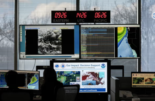
US Signals Potential Changes at NOAA
UConn Researchers Tracking Change in Precious Ecosystems
Primary forests are biodiversity hotspots and critical carbon stores, yet they face increasing anthropogenic threats. Researchers from the UConn Global Environmental Remote Sensing (GERS) Lab have developed a new remote sensing approach to track primary forest loss in Hispaniola (Haiti and the Dominican Republic) from 1996 to 2022. Using Landsat time-series data, the COLD algorithm, and machine learning, they mapped nearly three decades of deforestation, identifying fire (65%), logging, and hurricanes as key drivers.
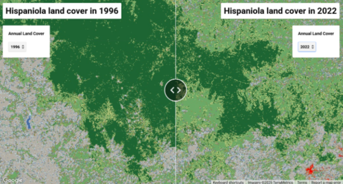
Map of land cover change in an area of the island of Hispaniola – Source: today.uconn.edu/Google Earth Engine
Their interactive map, found here, reveals patterns of fragmentation, showing that forests in flatter areas are most vulnerable to land use change and human-induced climate change. This study provides essential insights for biodiversity conservation and policy, with plans to expand mapping across the Caribbean. By continuously monitoring primary forests, the team aims to better understand and mitigate forest loss. View the entire article here to read more about the process involved in developing this map.
New UN Report Offers Insights into how Geospatial Technology can Advance Global Food Security
Satellites are revolutionizing global food security by providing advanced tools for agriculture, forestry, and land management. A new FAO and UNOOSA report highlights how space technology enables farmers and policymakers to monitor crops, manage water, control pests, and prepare for climate uncertainties.
With over 17,000 satellites launched since 1957, increasing precision and cloud-based applications have expanded access to geospatial data. The report, seen here, calls for strengthening global capacities, enhancing international collaboration on agriculture-focused satellites, and improving data accessibility.
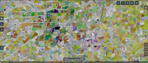
Satellite imagery of an area in Mexico – Source: FAO/SEPAL
FAO’s geospatial tools, like SEPAL for forest monitoring and WaPOR for tracking water use, bring satellite technology directly to farmers. The report emphasizes multi-stakeholder partnerships to optimize agrifood systems and ensure developing countries benefit from remote sensing. Standardized data, integration, and interoperability are essential for maximizing these innovations.
Read the full report here.
Lost Cities of the Amazon: Science is Revealing Ancient Garden Towns Hidden in the Rainforest
The Brazilian National Institute for Space Research has recently used Lidar datasets to discover traces of a lost world held within the Amazon. Evidence for as many as 24,000 earthworks that predate Columbus have been identified across the Amazon River basin that challenge the preexisting understanding of the history of the Earth’s greatest forest.
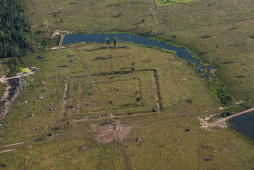
An aerial image of one of the recently discovered sites – Photography: David Gurgel
Lidar sensors attached to aircraft and drones were deployed to scan regions for radiocarbon dating, soil chemistry, and phytolith analysis, puzzle pieces that have allowed scientists to develop a better understanding of ancient Amazon basin cities than ever before. Without Lidar, it would have taken years of ground-level surveying in the Amazon River basin with a massive budget and workforce to uncover these secrets. Lidar allows large areas of land to be surveyed at once, enabling scientists to see structures beneath the forest canopy and the soil.
Click here to read the full article and to see the various models constructed from the lidar data that show what these ancient cities might have looked like.
UAE Begins Mapping Corridors for Air Taxis and Cargo Drones
The United Arab Emirates is taking a major step toward integrating air taxis and cargo drones into its transportation network by mapping dedicated aerial corridors, its civil aviation authority announced. This initiative aligns with the country’s vision of becoming a global leader in advanced air mobility.

Dubai first tested Volocopter’s flying taxis in 2017, and in 2023, U.S.-based Joby Aviation applied for certification to operate in the UAE. The newly planned air corridors—developed in collaboration with the Technology Innovation Institute (TII) and ASPIRE—are expected to be finalized within 20 months, with commercial air taxi services projected to launch by 2026.
Click here to view the full story.
Passive Radar Breaks New Ground in Avalanche Detection
Avalanches pose a significant threat in mountainous regions, making real-time monitoring essential for ensuring safety. Researchers at the Fraunhofer Institute for High-Frequency Physics and Radar Techniques FHR are pioneering a new approach using passive radar technology to improve avalanche detection.
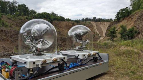
Passive radar pointed toward controlled landslide – Source: phys.org/Fraunhofer FHR/Diego Cristallini
By harnessing signals from satellite mega-constellations like Starlink and OneWeb, scientists can determine whether controlled detonations successfully trigger avalanches—even in remote areas lacking terrestrial infrastructure. Unlike traditional methods such as mechanical wires or helicopters, passive radar is cost-effective, weather-independent, and requires no transmission licenses.
A feasibility study by ESA-ESTEC confirms that these satellite networks can reliably support avalanche detection, marking a major breakthrough in mountain safety and risk mitigation. With passive radar, authorities can enhance monitoring efforts while reducing operational risks and costs.
To read more about this breakthrough click here to see the entire article.


Be the first to comment