
Technology

Mapping at McGill, Geospatial Index, Niagara Region, Elaine Dawson, Kamloops Transit, Konsberg Geospatial: Your Canadian Geomatics Briefing for May 2nd
In the Canadian geomatics sector this week, we look at the Geospatial Readiness Index, big data, new mapping initiatives, and…

Urthecast, Maxar, Climate Atlas, Hybrid GIS, ArcticDEM: Your Monday Briefing
In the news: Climate data and those who can access it, LiDar mapping at work in the Okanagan, and Business…

La révolution des données d’élévation du CCCOT, partie 2: ArcticDEM
Avec une superficie de plus de 4 millions de km² au nord du 60e parallèle, le Canada possède une des…
Traces of the Past: 1917 Vimy Ridge Map Project Video Presentation GoGeomatics in Ottawa
Bert de Bruijn is an Ottawa IT security consultant and founder of the WikiWar Project. Bert is passionate about Crowdsourcing…

CCMEO’s Elevation Data Revolution: Part 2 – ArcticDEM development
With more than 4 million km² of land above the 60th parallel, Canada has one of the largest Arctic regions…
La révolution des données d’élévation du CCCOT a commencé: nouveau MNÉ du Canada
Ohé le Canada: il est de nouveau temps de s’exciter sur les données d’élévation! Pendant des années, si ce n’est…
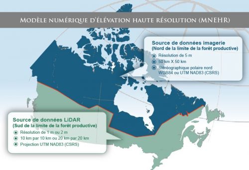
CCMEO’s Elevation Data Revolution has Begun: Canada’s New DEM
Cet article est aussi disponible en français: https://gogeomatics.ca/la-revolution-des-donnees-delevation-du-cccot-a-commence-nouveau-mne-du-canada/ Hey Canada: It’s time to get excited about elevation data again! For…

Calgary Geography of Health and GIS Analysis: Researchers map out seasonal surprise in city air quality
A University of Calgary study of seasonal air pollution will be of cold comfort to thousands of Calgarians living south of the…

Do You Care about Spatial Data and Canada’s Geospatial Data Infrastructure? If so take this survey
Here’s your chance to express your needs and priorities around geospatial data and spatial data infrastructure, and help shape future…

Les 5 = ensembles de données vectorielles SIG canadiens les plus populaires
Nous parlons ici de données vectorielles SIG. Il s’agit d’une sous-catégorie des données géospatiales que le Centre canadien de cartographie…
Using GIS to Examine Leapfrog Development Beyond the Ontario Greenbelt
Since its establishment by the Ontario government in 2005, the Places to Grow Act is a policy envisaged at curbing…
The Top 5 Most Popular Canadian GIS Vector Data Sets
We’re talking GIS vector data, it’s a subset of the geospatial data that NRCan’s Canada Centre for Mapping and Earth…
